Las Cañas geodata
Las Cañas (Guanajuato) is a populated place; located in Mexico in America/Mexico_City (GMT-6) time zone. With population of 1,093 people, there are 7958 cities with bigger population in this country. Compared to other cities in Mexico, 63.4% of cities are located further ↓South; 76.6% of cities are located further →East and 63.1% of cities have lower elevation than Las Cañas. Note1


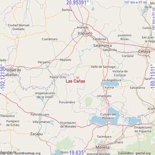
Las Cañas GPS coordinates[2]
20° 17' 45.096" North, 101° 25' 5.628" West
| Map corner | latitude | longitude |
|---|---|---|
| Upper-left | 20.95391°, | -102.12136° |
| Center: | 20.29586°, | -101.41823° |
| Lower-right: | 19.635°, | -100.71511° |
| Map W x H: | 146.6×146.7 km | = 91.1×91.2mi |
| max Lat: | 32.7° ⇑36.6% North |
| Las Cañas: | 20.29586° |
| min Lat: | ⇓63.4% South 14.53588° |
| min Long | Las Cañas | max Long |
| -117.105° | -101.41823° | -86.73105° |
| W 23.4%⇐ | ⇒76.6% E |
Elevation
Elevation of Las Cañas is 1780 m = 5840 ft, and this is 526.3 m = 1727 ft above average elevation for this country.
| Max E: |
3497 m = 11473 ft | 36.9% |
| Las Cañas | 1780 m 5840 ft | |
| Avg. | 1253.7 m = 4113 ft | |
Min E: |
-1 m = -3 ft | 63.1% |
See also: Mexico elevation on elevation.city.
Geographical zone
Las Cañas is located in North Torrid zone (between Equator and Tropic of Cancer). Distance of this Northern Tropic circle is 349.2 km =217 mi to North.| Distance of | km | miles | from Las Cañas |
|---|---|---|---|
| North Pole | 7750.4 | 4815.9 | to North |
| Arctic Circle | 5144.5 | 3196.6 | to North |
| Tropic Cancer | 349.2 | 217 | to North |
| Equator | 2256.7 | 1402.2 | to South |


Nearby cities:
15 places around Las Cañas: (largest is in red/bold)
• Chamacuero
9.7 km =6 mi,  169°
169°
• Cora
6.5 km =4 mi,  307°
307°
• El Pilar
6.2 km =3.9 mi,  164°
164°
• Guarapo
9.7 km =6 mi,  4°
4°
• Héroes de Chapultepec (Rodeo de San Antonio)
8.9 km =5.5 mi,  280°
280°
• Isaac Arriaga (Santa Ana Mancera)
9.6 km =6 mi,  234°
234°
• Jícamas
6.5 km =4 mi,  109°
109°
• La Soledad de Santa Ana
7.2 km =4.5 mi,  247°
247°
• Las Letras
7.4 km =4.6 mi,  192°
192°
• Las Raíces
6.8 km =4.2 mi,  347°
347°
• Las Sanguijuelas
3.6 km =2.2 mi, 190°
• Los Martínez
3.1 km =1.9 mi,  75°
75°
• Los Reyes
8.7 km =5.4 mi,  181°
181°
• Salitre de Aguilares
3.6 km =2.2 mi, 312°
• San José Huipana
5.8 km =3.6 mi, 249°
Sources, notices
• [Note1] Compared only with cities in Mexico existing in our database
• [Src1] Map data: © OpenStreetMap contributors (CC-BY-SA)
• [Src2] Other city data from geonames.org with taken over terms of usage.
• [Src3] Geographical zone / Annual Mean Temperature by Robert A. Rohde @ Wikipedia
