Las Sanguijuelas geodata
Las Sanguijuelas (Michoacán) is a populated place; located in Mexico in America/Mexico_City (GMT-6) time zone. With population of 773 people, there are 11306 cities with bigger population in this country. Compared to other cities in Mexico, 62.8% of cities are located further ↓South; 76.7% of cities are located further →East and 74.4% of cities have lower elevation than Las Sanguijuelas. Note1


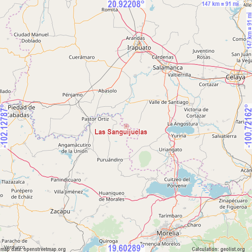
Las Sanguijuelas GPS coordinates[2]
20° 15' 50.004" North, 101° 25' 29.064" West
| Map corner | latitude | longitude |
|---|---|---|
| Upper-left | 20.92208°, | -102.12787° |
| Center: | 20.26389°, | -101.42474° |
| Lower-right: | 19.60289°, | -100.72162° |
| Map W x H: | 146.7×146.7 km | = 91.2×91.2mi |
| max Lat: | 32.7° ⇑37.2% North |
| Las Sanguijuelas: | 20.26389° |
| min Lat: | ⇓62.8% South 14.53588° |
| min Long | Las Sanguijuela | max Long |
| -117.105° | -101.42474° | -86.73105° |
| W 23.3%⇐ | ⇒76.7% E |
Elevation
Elevation of Las Sanguijuelas is 2020 m = 6627 ft, and this is 766.3 m = 2514 ft above average elevation for this country.
| Max E: |
3497 m = 11473 ft | 25.6% |
| Las Sanguijuelas | 2020 m 6627 ft | |
| Avg. | 1253.7 m = 4113 ft | |
Min E: |
-1 m = -3 ft | 74.4% |
See also: Mexico elevation on elevation.city.
Geographical zone
Las Sanguijuelas is located in North Torrid zone (between Equator and Tropic of Cancer). Distance of this Northern Tropic circle is 352.8 km =219.2 mi to North.| Distance of | km | miles | from Las Sanguijuelas |
|---|---|---|---|
| North Pole | 7753.9 | 4818 | to North |
| Arctic Circle | 5148 | 3198.8 | to North |
| Tropic Cancer | 352.8 | 219.2 | to North |
| Equator | 2253.1 | 1400 | to South |


Nearby cities:
15 places around Las Sanguijuelas: (largest is in red/bold)
• Chamacuero
6.5 km =4 mi,  158°
158°
• Cora
8.7 km =5.4 mi,  329°
329°
• El Pilar
3.4 km =2.1 mi,  135°
135°
• Isaac Arriaga (Santa Ana Mancera)
7.5 km =4.7 mi,  254°
254°
• Jícamas
7 km =4.3 mi,  78°
78°
• La Soledad de Santa Ana
6 km =3.7 mi,  277°
277°
• Laguna Prieta
9.6 km =6 mi,  122°
122°
• Las Cañas
3.6 km =2.2 mi,  10°
10°
• Las Letras
3.8 km =2.4 mi,  194°
194°
• Las Ranas
8.3 km =5.2 mi,  222°
222°
• Los Martínez
5.7 km =3.5 mi,  40°
40°
• Los Reyes
5.1 km =3.2 mi,  174°
174°
• Salitre de Aguilares
6.3 km =3.9 mi,  342°
342°
• San José Huipana
4.9 km =3 mi,  287°
287°
• Santa Clara
9.5 km =5.9 mi, 185°
Sources, notices
• [Note1] Compared only with cities in Mexico existing in our database
• [Src1] Map data: © OpenStreetMap contributors (CC-BY-SA)
• [Src2] Other city data from geonames.org with taken over terms of usage.
• [Src3] Geographical zone / Annual Mean Temperature by Robert A. Rohde @ Wikipedia
