El Terrero geodata
El Terrero (Chihuahua) is a populated place; located in Mexico in America/Chihuahua (GMT-6) time zone. With population of 2,621 people, there are 3379 cities with bigger population in this country. Compared to other cities in Mexico, 98.1% of cities are located further ↓South; 94.8% of cities are located further →East and 66.1% of cities have lower elevation than El Terrero. Note1


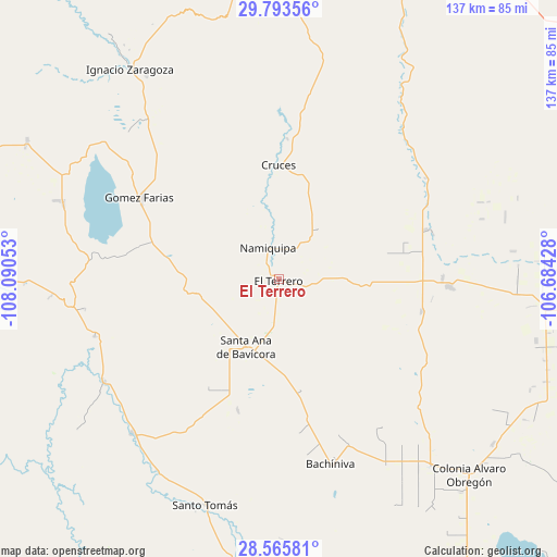
El Terrero GPS coordinates[2]
29° 10' 53.472" North, 107° 23' 14.64" West
| Map corner | latitude | longitude |
|---|---|---|
| Upper-left | 29.79356°, | -108.09053° |
| Center: | 29.18152°, | -107.3874° |
| Lower-right: | 28.56581°, | -106.68428° |
| Map W x H: | 136.5×136.5 km | = 84.8×84.8mi |
| max Lat: | 32.7° ⇑1.9% North |
| El Terrero: | 29.18152° |
| min Lat: | ⇓98.1% South 14.53588° |
| min Long | El Terrero | max Long |
| -117.105° | -107.3874° | -86.73105° |
| W 5.2%⇐ | ⇒94.8% E |
Elevation
Elevation of El Terrero is 1853 m = 6079 ft, and this is 599.3 m = 1966 ft above average elevation for this country.
| Max E: |
3497 m = 11473 ft | 33.9% |
| El Terrero | 1853 m 6079 ft | |
| Avg. | 1253.7 m = 4113 ft | |
Min E: |
-1 m = -3 ft | 66.1% |
See also: Mexico elevation on elevation.city.
Geographical zone
El Terrero is located in North temperate zone (between Tropic of Cancer and the Arctic Circle). Distance of this Northern Tropic circle is 638.8 km =396.9 mi to South.| Distance of | km | miles | from El Terrero |
|---|---|---|---|
| North Pole | 6762.4 | 4202 | to North |
| Arctic Circle | 4156.5 | 2582.7 | to North |
| Tropic Cancer | 638.8 | 396.9 | to South |
| Equator | 3244.7 | 2016.2 | to South |


Nearby cities:
15 places around El Terrero: (largest is in red/bold)
• Abraham González
23.2 km =14.4 mi,  190°
190°
• Bachíniva
47.7 km =29.6 mi,  164°
164°
• Benito Juárez
41.7 km =25.9 mi,  92°
92°
• El Molino
2.2 km =1.4 mi,  301°
301°
• Gómez Farías
39.5 km =24.5 mi, 300°
• Independencia
18.1 km =11.2 mi,  236°
236°
• La Pinta
28.2 km =17.5 mi,  281°
281°
• Las Cruces
27.9 km =17.3 mi,  359°
359°
• Lázaro Cárdenas
35.9 km =22.3 mi,  102°
102°
• Namiquipa
8.2 km =5.1 mi,  341°
341°
• Oscar Soto Maynez
18.8 km =11.7 mi,  206°
206°
• Peña Blanca
33.7 km =20.9 mi,  290°
290°
• San José Bavícora
35.7 km =22.2 mi, 282°
• Santa Catalina de Villela
40.2 km =25 mi, 90°
• Temósachic
49.8 km =30.9 mi, 239°
Sources, notices
• [Note1] Compared only with cities in Mexico existing in our database
• [Src1] Map data: © OpenStreetMap contributors (CC-BY-SA)
• [Src2] Other city data from geonames.org with taken over terms of usage.
• [Src3] Geographical zone / Annual Mean Temperature by Robert A. Rohde @ Wikipedia
