Hostotipaquillo geodata
Hostotipaquillo (Jalisco) is a seat of a second-order administrative division; located in Mexico in America/Mexico_City (GMT-6) time zone. With population of 3,762 people, there are 2438 cities with bigger population in this country. Compared to other cities in Mexico, 77.3% of cities are located further ↓South; 90.1% of cities are located further →East and 52.7% of cities have higher elevation than Hostotipaquillo. Note1


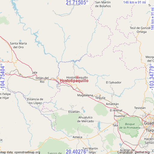
Hostotipaquillo GPS coordinates[2]
21° 3' 37.26" North, 104° 3' 3.276" West
| Map corner | latitude | longitude |
|---|---|---|
| Upper-left | 21.71505°, | -104.75404° |
| Center: | 21.06035°, | -104.05091° |
| Lower-right: | 20.40276°, | -103.34779° |
| Map W x H: | 145.9×145.9 km | = 90.7×90.7mi |
| max Lat: | 32.7° ⇑22.7% North |
| Hostotipaquillo: | 21.06035° |
| min Lat: | ⇓77.3% South 14.53588° |
| min Long | Hostotipaquillo | max Long |
| -117.105° | -104.05091° | -86.73105° |
| W 9.9%⇐ | ⇒90.1% E |
Elevation
Elevation of Hostotipaquillo is 1303 m = 4275 ft, and this is 49.3 m = 162 ft above average elevation for this country.
| Max E: |
3497 m = 11473 ft | 52.7% |
| Hostotipaquillo | 1303 m 4275 ft | |
| Avg. | 1253.7 m = 4113 ft | |
Min E: |
-1 m = -3 ft | 47.3% |
See also: Mexico elevation on elevation.city.
Geographical zone
Hostotipaquillo is located in North Torrid zone (between Equator and Tropic of Cancer). Distance of this Northern Tropic circle is 264.2 km =164.2 mi to North.| Distance of | km | miles | from Hostotipaquillo |
|---|---|---|---|
| North Pole | 7665.4 | 4763.1 | to North |
| Arctic Circle | 5059.5 | 3143.8 | to North |
| Tropic Cancer | 264.2 | 164.2 | to North |
| Equator | 2341.7 | 1455.1 | to South |


Nearby cities:
15 places around Hostotipaquillo: (largest is in red/bold)
• El Llano de los Vela
15.6 km =9.7 mi,  115°
115°
• La Estancia de Ayones
20.2 km =12.6 mi,  190°
190°
• La Joya
25 km =15.5 mi,  162°
162°
• La Mazata
20.5 km =12.7 mi, 191°
• La Mesa de Flores
14.6 km =9.1 mi,  343°
343°
• La Quemada
9.9 km =6.2 mi,  178°
178°
• La Venta de Nochitiltic
10.9 km =6.8 mi,  244°
244°
• Magdalena
18.6 km =11.6 mi, 156°
• San Andrés
15.6 km =9.7 mi, 194°
• San Martín de las Cañas
23.8 km =14.8 mi, 122°
• San Pedro
26.9 km =16.7 mi, 182°
• San Simón
8.9 km =5.5 mi,  151°
151°
• Santa Rosalía
27.3 km =17 mi, 187°
• Santa Teresa
23 km =14.3 mi,  134°
134°
• Santo Tomás
9.7 km =6 mi,  223°
223°
Sources, notices
• [Note1] Compared only with cities in Mexico existing in our database
• [Src1] Map data: © OpenStreetMap contributors (CC-BY-SA)
• [Src2] Other city data from geonames.org with taken over terms of usage.
• [Src3] Geographical zone / Annual Mean Temperature by Robert A. Rohde @ Wikipedia
