Esmeralda geodata
Esmeralda (Durango) is a populated place; located in Mexico in America/Monterrey (GMT-6) time zone. With population of 2,249 people, there are 3909 cities with bigger population in this country. Compared to other cities in Mexico, 93.9% of cities are located further ↓South; 88% of cities are located further →East and 57.5% of cities have higher elevation than Esmeralda. Note1


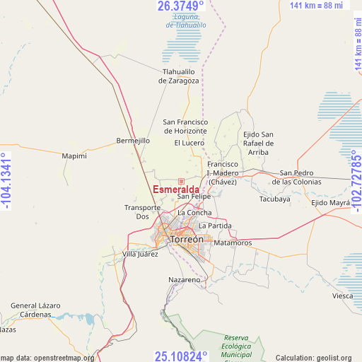
Esmeralda GPS coordinates[2]
25° 44' 35.736" North, 103° 25' 51.492" West
| Map corner | latitude | longitude |
|---|---|---|
| Upper-left | 26.3749°, | -104.1341° |
| Center: | 25.74326°, | -103.43097° |
| Lower-right: | 25.10824°, | -102.72785° |
| Map W x H: | 140.8×140.8 km | = 87.5×87.5mi |
| max Lat: | 32.7° ⇑6.1% North |
| Esmeralda: | 25.74326° |
| min Lat: | ⇓93.9% South 14.53588° |
| min Long | Esmeralda | max Long |
| -117.105° | -103.43097° | -86.73105° |
| W 12%⇐ | ⇒88% E |
Elevation
Elevation of Esmeralda is 1113 m = 3652 ft, and this is 140.7 m = 462 ft below average elevation for this country.
| Max E: |
3497 m = 11473 ft | 57.5% |
| Avg. | 1253.7 m = 4113 ft | |
| Esmeralda | 1113 m = 3652 ft | |
Min E: |
-1 m = -3 ft | 42.5% |
See also: Mexico elevation on elevation.city.
Geographical zone
Esmeralda is located in North temperate zone (between Tropic of Cancer and the Arctic Circle). Distance of this Northern Tropic circle is 256.5 km =159.4 mi to South.| Distance of | km | miles | from Esmeralda |
|---|---|---|---|
| North Pole | 7144.7 | 4439.5 | to North |
| Arctic Circle | 4538.8 | 2820.3 | to North |
| Tropic Cancer | 256.5 | 159.4 | to South |
| Equator | 2862.4 | 1778.6 | to South |


Nearby cities:
15 places around Esmeralda: (largest is in red/bold)
• Arcinas
4.2 km =2.6 mi,  31°
31°
• California
5.9 km =3.7 mi,  70°
70°
• El Castillo
8.6 km =5.3 mi,  176°
176°
• El Pilar
8.5 km =5.3 mi,  109°
109°
• El Quemado
6.3 km =3.9 mi,  124°
124°
• El Vergelito
3 km =1.9 mi,  193°
193°
• Eureka de Media Luna (Eureka)
8.4 km =5.2 mi,  42°
42°
• La Popular
7.9 km =4.9 mi,  206°
206°
• La Tehua
3.4 km =2.1 mi,  172°
172°
• Reforma
6.2 km =3.9 mi, 115°
• San Felipe
7.4 km =4.6 mi,  139°
139°
• Santa Cruz Luján
7.5 km =4.7 mi, 105°
• Valle de Eureka
8.9 km =5.5 mi,  22°
22°
• Venecia
8.8 km =5.5 mi,  63°
63°
• Villa Gregorio García
8 km =5 mi,  82°
82°
Sources, notices
• [Note1] Compared only with cities in Mexico existing in our database
• [Src1] Map data: © OpenStreetMap contributors (CC-BY-SA)
• [Src2] Other city data from geonames.org with taken over terms of usage.
• [Src3] Geographical zone / Annual Mean Temperature by Robert A. Rohde @ Wikipedia
