La Peña geodata
La Peña (Durango) is a populated place; located in Mexico in America/Monterrey (GMT-6) time zone. With population of 601 people, there are 14318 cities with bigger population in this country. Compared to other cities in Mexico, 89.1% of cities are located further ↓South; 92.9% of cities are located further →East and 98.2% of cities have lower elevation than La Peña. Note1


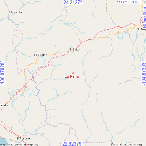
La Peña GPS coordinates[2]
23° 34' 11.388" North, 105° 22' 34.14" West
| Map corner | latitude | longitude |
|---|---|---|
| Upper-left | 24.2127°, | -106.07928° |
| Center: | 23.56983°, | -105.37615° |
| Lower-right: | 22.92379°, | -104.67303° |
| Map W x H: | 143.3×143.3 km | = 89×89mi |
| max Lat: | 32.7° ⇑10.9% North |
| La Peña: | 23.56983° |
| min Lat: | ⇓89.1% South 14.53588° |
| min Long | La Peña | max Long |
| -117.105° | -105.37615° | -86.73105° |
| W 7.1%⇐ | ⇒92.9% E |
Elevation
Elevation of La Peña is 2759 m = 9052 ft, and this is 1505.3 m = 4939 ft above average elevation for this country.
| Max E: |
3497 m = 11473 ft | 1.8% |
| La Peña | 2759 m 9052 ft | |
| Avg. | 1253.7 m = 4113 ft | |
Min E: |
-1 m = -3 ft | 98.2% |
See also: Mexico elevation on elevation.city.
Geographical zone
La Peña is located in North temperate zone (between Tropic of Cancer and the Arctic Circle). Distance of this Northern Tropic circle is 14.8 km =9.2 mi to South.| Distance of | km | miles | from La Peña |
|---|---|---|---|
| North Pole | 7386.3 | 4589.6 | to North |
| Arctic Circle | 4780.5 | 2970.5 | to North |
| Tropic Cancer | 14.8 | 9.2 | to South |
| Equator | 2620.7 | 1628.4 | to South |


Nearby cities:
15 places around La Peña: (largest is in red/bold)
• Banderas del Águila
39.8 km =24.7 mi,  5°
5°
• Chavarría Nuevo
23.6 km =14.7 mi,  292°
292°
• El Mil Diez
25.6 km =15.9 mi,  357°
357°
• El Palmito
47 km =29.2 mi,  268°
268°
• El Salto
23.2 km =14.4 mi,  3°
3°
• Estación Coyotes (José María Morelos)
33.3 km =20.7 mi, 10°
• La Ciudad
36.5 km =22.7 mi,  299°
299°
• La Petaca
46.4 km =28.8 mi,  249°
249°
• Llano Grande
37 km =23 mi,  27°
27°
• Llano Grande de Milpillas Chico
38.3 km =23.8 mi,  117°
117°
• Mesa de San Pedro
29.9 km =18.6 mi,  228°
228°
• Potrerillos
47.9 km =29.8 mi, 254°
• Pueblo Nuevo
21.2 km =13.2 mi,  181°
181°
• San Bernardino de Milpillas Chico
30.7 km =19.1 mi,  132°
132°
• San Jerónimo
31.9 km =19.8 mi,  327°
327°
Sources, notices
• [Note1] Compared only with cities in Mexico existing in our database
• [Src1] Map data: © OpenStreetMap contributors (CC-BY-SA)
• [Src2] Other city data from geonames.org with taken over terms of usage.
• [Src3] Geographical zone / Annual Mean Temperature by Robert A. Rohde @ Wikipedia
