Potrerillos geodata
Potrerillos (Sinaloa) is a populated place; located in Mexico in America/Mazatlan (GMT-7) time zone. With population of 502 people, there are 16762 cities with bigger population in this country. Compared to other cities in Mexico, 88.9% of cities are located further ↓South; 93.6% of cities are located further →East and 51.9% of cities have lower elevation than Potrerillos. Note1


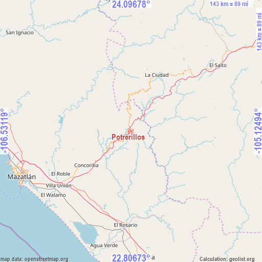
Potrerillos GPS coordinates[2]
23° 27' 11.988" North, 105° 49' 41.016" West
| Map corner | latitude | longitude |
|---|---|---|
| Upper-left | 24.09678°, | -106.53119° |
| Center: | 23.45333°, | -105.82806° |
| Lower-right: | 22.80673°, | -105.12494° |
| Map W x H: | 143.4×143.4 km | = 89.1×89.1mi |
| max Lat: | 32.7° ⇑11.1% North |
| Potrerillos: | 23.45333° |
| min Lat: | ⇓88.9% South 14.53588° |
| min Long | Potrerillos | max Long |
| -117.105° | -105.82806° | -86.73105° |
| W 6.4%⇐ | ⇒93.6% E |
Elevation
Elevation of Potrerillos is 1522 m = 4993 ft, and this is 268.3 m = 880 ft above average elevation for this country.
| Max E: |
3497 m = 11473 ft | 48.1% |
| Potrerillos | 1522 m 4993 ft | |
| Avg. | 1253.7 m = 4113 ft | |
Min E: |
-1 m = -3 ft | 51.9% |
See also: Mexico elevation on elevation.city.
Geographical zone
Potrerillos is located in North temperate zone (between Tropic of Cancer and the Arctic Circle). Distance of this Northern Tropic circle is 1.8 km =1.1 mi to South.| Distance of | km | miles | from Potrerillos |
|---|---|---|---|
| North Pole | 7399.3 | 4597.7 | to North |
| Arctic Circle | 4793.4 | 2978.5 | to North |
| Tropic Cancer | 1.8 | 1.1 | to South |
| Equator | 2607.8 | 1620.4 | to South |


Nearby cities:
15 places around Potrerillos: (largest is in red/bold)
• Chavarría Nuevo
32.6 km =20.3 mi,  47°
47°
• Chele
28.4 km =17.6 mi,  193°
193°
• Concordia
30.4 km =18.9 mi,  232°
232°
• Copala
12.6 km =7.8 mi,  239°
239°
• El Palmito
12.2 km =7.6 mi,  355°
355°
• El Tecomate de la Noria
32 km =19.9 mi,  317°
317°
• El Verde
32.8 km =20.4 mi,  252°
252°
• La Ciudad
33.9 km =21.1 mi,  24°
24°
• La Concepción
35.4 km =22 mi,  259°
259°
• La Petaca
3.9 km =2.4 mi,  139°
139°
• Malpica
38 km =23.6 mi, 234°
• Mesa de San Pedro
24.6 km =15.3 mi,  106°
106°
• Mesillas
32.1 km =19.9 mi,  224°
224°
• Santa Lucía
3.1 km =1.9 mi, 235°
• Zavala
31.4 km =19.5 mi, 248°
Sources, notices
• [Note1] Compared only with cities in Mexico existing in our database
• [Src1] Map data: © OpenStreetMap contributors (CC-BY-SA)
• [Src2] Other city data from geonames.org with taken over terms of usage.
• [Src3] Geographical zone / Annual Mean Temperature by Robert A. Rohde @ Wikipedia
