La Loma geodata
La Loma (Jalisco) is a populated place; located in Mexico in America/Mexico_City (GMT-6) time zone. With population of 629 people, there are 13762 cities with bigger population in this country. Compared to other cities in Mexico, 69.5% of cities are located further ↓South; 86.1% of cities are located further →East and 50.7% of cities have lower elevation than La Loma. Note1


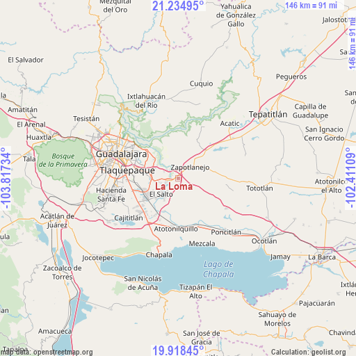
La Loma GPS coordinates[2]
20° 34' 41.232" North, 103° 6' 51.156" West
| Map corner | latitude | longitude |
|---|---|---|
| Upper-left | 21.23495°, | -103.81734° |
| Center: | 20.57812°, | -103.11421° |
| Lower-right: | 19.91845°, | -102.41109° |
| Map W x H: | 146.4×146.4 km | = 91×91mi |
| max Lat: | 32.7° ⇑30.5% North |
| La Loma: | 20.57812° |
| min Lat: | ⇓69.5% South 14.53588° |
| min Long | La Loma | max Long |
| -117.105° | -103.11421° | -86.73105° |
| W 13.9%⇐ | ⇒86.1% E |
Elevation
Elevation of La Loma is 1473 m = 4833 ft, and this is 219.3 m = 719 ft above average elevation for this country.
| Max E: |
3497 m = 11473 ft | 49.3% |
| La Loma | 1473 m 4833 ft | |
| Avg. | 1253.7 m = 4113 ft | |
Min E: |
-1 m = -3 ft | 50.7% |
See also: Mexico elevation on elevation.city.
Geographical zone
La Loma is located in North Torrid zone (between Equator and Tropic of Cancer). Distance of this Northern Tropic circle is 317.8 km =197.5 mi to North.| Distance of | km | miles | from La Loma |
|---|---|---|---|
| North Pole | 7719 | 4796.4 | to North |
| Arctic Circle | 5113.1 | 3177.1 | to North |
| Tropic Cancer | 317.8 | 197.5 | to North |
| Equator | 2288.1 | 1421.8 | to South |


Nearby cities:
15 places around La Loma: (largest is in red/bold)
• Agua Escondida
8 km =5 mi,  157°
157°
• Centro de Readaptación Social
8.7 km =5.4 mi,  252°
252°
• Cerro Santa Fe
6.6 km =4.1 mi,  151°
151°
• El Salitre
3.3 km =2.1 mi, 153°
• El Salto
9.6 km =6 mi,  226°
226°
• El Vado
5.6 km =3.5 mi,  308°
308°
• Juanacatlán
9.7 km =6 mi,  217°
217°
• La Laja
0.8 km =0.5 mi,  285°
285°
• La Mezquitera
2.2 km =1.4 mi,  175°
175°
• La Paz
7.7 km =4.8 mi,  123°
123°
• Mismaloya (Fraccionamiento Pedregal de Santa Martha)
6.8 km =4.2 mi,  298°
298°
• Paseo Puente Viejo
8 km =5 mi,  262°
262°
• Pueblos de la Barranca (El Maestranzo)
2.5 km =1.6 mi, 288°
• Puente Grande
4.2 km =2.6 mi, 257°
• Zapotlanejo
6.9 km =4.3 mi,  44°
44°
Sources, notices
• [Note1] Compared only with cities in Mexico existing in our database
• [Src1] Map data: © OpenStreetMap contributors (CC-BY-SA)
• [Src2] Other city data from geonames.org with taken over terms of usage.
• [Src3] Geographical zone / Annual Mean Temperature by Robert A. Rohde @ Wikipedia
