La Paz geodata
La Paz (Jalisco) is a populated place; located in Mexico in America/Mexico_City (GMT-6) time zone. With population of 1,043 people, there are 8357 cities with bigger population in this country. Compared to other cities in Mexico, 68.7% of cities are located further ↓South; 85.9% of cities are located further →East and 51.3% of cities have lower elevation than La Paz. Note1


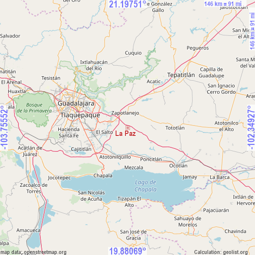
La Paz GPS coordinates[2]
20° 32' 25.872" North, 103° 3' 8.604" West
| Map corner | latitude | longitude |
|---|---|---|
| Upper-left | 21.19751°, | -103.75552° |
| Center: | 20.54052°, | -103.05239° |
| Lower-right: | 19.88069°, | -102.34927° |
| Map W x H: | 146.4×146.4 km | = 91×91mi |
| max Lat: | 32.7° ⇑31.3% North |
| La Paz: | 20.54052° |
| min Lat: | ⇓68.7% South 14.53588° |
| min Long | La Paz | max Long |
| -117.105° | -103.05239° | -86.73105° |
| W 14.1%⇐ | ⇒85.9% E |
Elevation
Elevation of La Paz is 1499 m = 4918 ft, and this is 245.3 m = 805 ft above average elevation for this country.
| Max E: |
3497 m = 11473 ft | 48.7% |
| La Paz | 1499 m 4918 ft | |
| Avg. | 1253.7 m = 4113 ft | |
Min E: |
-1 m = -3 ft | 51.3% |
See also: Mexico elevation on elevation.city.
Geographical zone
La Paz is located in North Torrid zone (between Equator and Tropic of Cancer). Distance of this Northern Tropic circle is 322 km =200.1 mi to North.| Distance of | km | miles | from La Paz |
|---|---|---|---|
| North Pole | 7723.2 | 4799 | to North |
| Arctic Circle | 5117.3 | 3179.7 | to North |
| Tropic Cancer | 322 | 200.1 | to North |
| Equator | 2283.9 | 1419.1 | to South |


Nearby cities:
15 places around La Paz: (largest is in red/bold)
• Agua Escondida
4.7 km =2.9 mi,  227°
227°
• Cerro Santa Fe
3.7 km =2.3 mi,  244°
244°
• Chila
12.3 km =7.6 mi,  136°
136°
• El Salitre
5.1 km =3.2 mi,  284°
284°
• El Salto
13.7 km =8.5 mi,  259°
259°
• El Vado
13.2 km =8.2 mi,  305°
305°
• Juanacatlán
12.8 km =8 mi,  254°
254°
• La Laja
8.5 km =5.3 mi,  301°
301°
• La Loma
7.7 km =4.8 mi, 303°
• La Mezquitera
6.6 km =4.1 mi,  287°
287°
• Pueblos de la Barranca (El Maestranzo)
10.1 km =6.3 mi, 299°
• Puente Grande
11 km =6.8 mi, 287°
• San Joaquín Zorrillos
9.7 km =6 mi,  23°
23°
• Tecualtitán
13 km =8.1 mi,  168°
168°
• Zapotlanejo
9.3 km =5.8 mi,  350°
350°
Sources, notices
• [Note1] Compared only with cities in Mexico existing in our database
• [Src1] Map data: © OpenStreetMap contributors (CC-BY-SA)
• [Src2] Other city data from geonames.org with taken over terms of usage.
• [Src3] Geographical zone / Annual Mean Temperature by Robert A. Rohde @ Wikipedia
