Lagunillas geodata
Lagunillas (Guanajuato) is a populated place; located in Mexico in America/Mexico_City (GMT-6) time zone. With population of 552 people, there are 15449 cities with bigger population in this country. Compared to other cities in Mexico, 79.1% of cities are located further ↓South; 79.5% of cities are located further →East and 77% of cities have lower elevation than Lagunillas. Note1


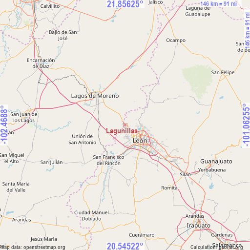
Lagunillas GPS coordinates[2]
21° 12' 7.884" North, 101° 45' 56.412" West
| Map corner | latitude | longitude |
|---|---|---|
| Upper-left | 21.85625°, | -102.4688° |
| Center: | 21.20219°, | -101.76567° |
| Lower-right: | 20.54522°, | -101.06255° |
| Map W x H: | 145.8×145.8 km | = 90.6×90.6mi |
| max Lat: | 32.7° ⇑20.9% North |
| Lagunillas: | 21.20219° |
| min Lat: | ⇓79.1% South 14.53588° |
| min Long | Lagunillas | max Long |
| -117.105° | -101.76567° | -86.73105° |
| W 20.5%⇐ | ⇒79.5% E |
Elevation
Elevation of Lagunillas is 2069 m = 6788 ft, and this is 815.3 m = 2675 ft above average elevation for this country.
| Max E: |
3497 m = 11473 ft | 23% |
| Lagunillas | 2069 m 6788 ft | |
| Avg. | 1253.7 m = 4113 ft | |
Min E: |
-1 m = -3 ft | 77% |
See also: Mexico elevation on elevation.city.
Geographical zone
Lagunillas is located in North Torrid zone (between Equator and Tropic of Cancer). Distance of this Northern Tropic circle is 248.5 km =154.4 mi to North.| Distance of | km | miles | from Lagunillas |
|---|---|---|---|
| North Pole | 7649.6 | 4753.2 | to North |
| Arctic Circle | 5043.7 | 3134 | to North |
| Tropic Cancer | 248.5 | 154.4 | to North |
| Equator | 2357.5 | 1464.9 | to South |


Nearby cities:
15 places around Lagunillas: (largest is in red/bold)
• Barranca de Venaderos
9.9 km =6.2 mi,  165°
165°
• Centro Familiar la Soledad
7.7 km =4.8 mi, 167°
• Ejido la Joya
7.1 km =4.4 mi,  157°
157°
• El Penitente
13.5 km =8.4 mi,  100°
100°
• El Saucillo de Primavera
3 km =1.9 mi,  265°
265°
• Fraccionamiento Paseo de las Torres
3.8 km =2.4 mi, 168°
• Hacienda Arriba
7.3 km =4.5 mi,  61°
61°
• Ibarrilla
12.6 km =7.8 mi, 97°
• La Ermita
6.5 km =4 mi,  148°
148°
• La Patiña
6.5 km =4 mi,  94°
94°
• Las Cruces
9.6 km =6 mi,  286°
286°
• León de los Aldama
12.5 km =7.8 mi,  130°
130°
• Real de la Joya
5.6 km =3.5 mi, 172°
• Rivera del Carmen (Divina Infantita)
13.3 km =8.3 mi, 99°
• Rizos de la Joya (Rizos del Saucillo)
6 km =3.7 mi,  176°
176°
Sources, notices
• [Note1] Compared only with cities in Mexico existing in our database
• [Src1] Map data: © OpenStreetMap contributors (CC-BY-SA)
• [Src2] Other city data from geonames.org with taken over terms of usage.
• [Src3] Geographical zone / Annual Mean Temperature by Robert A. Rohde @ Wikipedia
