Lagunillas geodata
Lagunillas (Guerrero) is a populated place; located in Mexico in America/Mexico_City (GMT-6) time zone. With population of 1,410 people, there are 6134 cities with bigger population in this country. Compared to other cities in Mexico, 80.3% of cities are located further ↑North; 79.1% of cities are located further →East and 84.3% of cities have higher elevation than Lagunillas. Note1


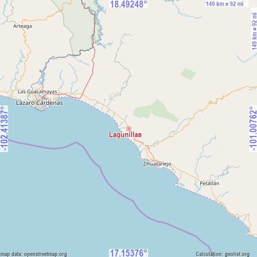
Lagunillas GPS coordinates[2]
17° 49' 27.768" North, 101° 42' 38.664" West
| Map corner | latitude | longitude |
|---|---|---|
| Upper-left | 18.49248°, | -102.41387° |
| Center: | 17.82438°, | -101.71074° |
| Lower-right: | 17.15376°, | -101.00762° |
| Map W x H: | 148.9×148.9 km | = 92.5×92.5mi |
| max Lat: | 32.7° ⇑80.3% North |
| Lagunillas: | 17.82438° |
| min Lat: | ⇓19.7% South 14.53588° |
| min Long | Lagunillas | max Long |
| -117.105° | -101.71074° | -86.73105° |
| W 20.9%⇐ | ⇒79.1% E |
Elevation
Elevation of Lagunillas is 50 m = 164 ft, and this is 1203.7 m = 3949 ft below average elevation for this country.
| Max E: |
3497 m = 11473 ft | 84.3% |
| Avg. | 1253.7 m = 4113 ft | |
| Lagunillas | 50 m = 164 ft | |
Min E: |
-1 m = -3 ft | 15.7% |
See also: Mexico elevation on elevation.city.
Geographical zone
Lagunillas is located in North Torrid zone (between Equator and Tropic of Cancer). Distance of this Northern Tropic circle is 624 km =387.7 mi to North.| Distance of | km | miles | from Lagunillas |
|---|---|---|---|
| North Pole | 8025.2 | 4986.6 | to North |
| Arctic Circle | 5419.3 | 3367.4 | to North |
| Tropic Cancer | 624 | 387.7 | to North |
| Equator | 1981.9 | 1231.5 | to South |


Nearby cities:
15 places around Lagunillas: (largest is in red/bold)
• Barbulillas
18.8 km =11.7 mi,  145°
145°
• Barrio Nuevo
13.9 km =8.6 mi, 145°
• El Coacoyul
32.4 km =20.1 mi,  129°
129°
• El Posquelite
22.6 km =14 mi,  137°
137°
• Ixtapa
18.9 km =11.7 mi,  157°
157°
• Ixtapa-Zihuatanejo
26.2 km =16.3 mi, 140°
• Joluta
28.8 km =17.9 mi,  307°
307°
• La Salitrera
16.4 km =10.2 mi, 135°
• La Unión
20.6 km =12.8 mi,  330°
330°
• Los Llanos de Temalhuacán (Los Llanos)
5.3 km =3.3 mi, 330°
• Los Reyes (Las Chiveras)
31 km =19.3 mi, 131°
• Pantla
12.4 km =7.7 mi, 140°
• Rincón de Cucharatepec
29.7 km =18.5 mi, 325°
• San José Ixtapa (Barrio Viejo)
16.7 km =10.4 mi, 144°
• Troncones
5.1 km =3.2 mi,  191°
191°
Sources, notices
• [Note1] Compared only with cities in Mexico existing in our database
• [Src1] Map data: © OpenStreetMap contributors (CC-BY-SA)
• [Src2] Other city data from geonames.org with taken over terms of usage.
• [Src3] Geographical zone / Annual Mean Temperature by Robert A. Rohde @ Wikipedia
