La Goleta geodata
La Goleta (Michoacán) is a populated place; located in Mexico in America/Mexico_City (GMT-6) time zone. With population of 1,815 people, there are 4798 cities with bigger population in this country. Compared to other cities in Mexico, 51.3% of cities are located further ↓South; 74.1% of cities are located further →East and 67.4% of cities have lower elevation than La Goleta. Note1


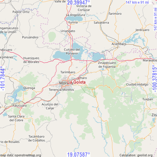
La Goleta GPS coordinates[2]
19° 44' 20.544" North, 101° 4' 52.572" West
| Map corner | latitude | longitude |
|---|---|---|
| Upper-left | 20.39947°, | -101.7844° |
| Center: | 19.73904°, | -101.08127° |
| Lower-right: | 19.07587°, | -100.37815° |
| Map W x H: | 147.2×147.2 km | = 91.5×91.5mi |
| max Lat: | 32.7° ⇑48.7% North |
| La Goleta: | 19.73904° |
| min Lat: | ⇓51.3% South 14.53588° |
| min Long | La Goleta | max Long |
| -117.105° | -101.08127° | -86.73105° |
| W 25.9%⇐ | ⇒74.1% E |
Elevation
Elevation of La Goleta is 1878 m = 6161 ft, and this is 624.3 m = 2048 ft above average elevation for this country.
| Max E: |
3497 m = 11473 ft | 32.6% |
| La Goleta | 1878 m 6161 ft | |
| Avg. | 1253.7 m = 4113 ft | |
Min E: |
-1 m = -3 ft | 67.4% |
See also: Mexico elevation on elevation.city.
Geographical zone
La Goleta is located in North Torrid zone (between Equator and Tropic of Cancer). Distance of this Northern Tropic circle is 411.1 km =255.4 mi to North.| Distance of | km | miles | from La Goleta |
|---|---|---|---|
| North Pole | 7812.3 | 4854.3 | to North |
| Arctic Circle | 5206.4 | 3235.1 | to North |
| Tropic Cancer | 411.1 | 255.4 | to North |
| Equator | 2194.8 | 1363.8 | to South |


Nearby cities:
15 places around La Goleta: (largest is in red/bold)
• Atapaneo
3.6 km =2.2 mi,  269°
269°
• Campestre Tarímbaro
6.4 km =4 mi,  308°
308°
• Cañadas del Bosque
1.9 km =1.2 mi,  226°
226°
• Charo
3.9 km =2.4 mi,  72°
72°
• Colonia José Vasconcelos
3.7 km =2.3 mi, 310°
• Colonia Miguel Hidalgo
5.6 km =3.5 mi,  337°
337°
• El Cuitzillo Grande
5.9 km =3.7 mi,  320°
320°
• Fraccionamiento Laureles Eréndira
6.3 km =3.9 mi, 305°
• Fraccionamiento Misión del Valle
5.2 km =3.2 mi,  304°
304°
• Irapeo
5.6 km =3.5 mi,  154°
154°
• Jaripeo
6.6 km =4.1 mi,  183°
183°
• La Aldea
5.6 km =3.5 mi, 274°
• San Antonio Corrales (Nuevo Coronillas)
5.5 km =3.4 mi,  44°
44°
• Tres Marías
5.4 km =3.4 mi,  222°
222°
• Uruétaro
5.8 km =3.6 mi,  353°
353°
Sources, notices
• [Note1] Compared only with cities in Mexico existing in our database
• [Src1] Map data: © OpenStreetMap contributors (CC-BY-SA)
• [Src2] Other city data from geonames.org with taken over terms of usage.
• [Src3] Geographical zone / Annual Mean Temperature by Robert A. Rohde @ Wikipedia
