Juan Lucas geodata
Juan Lucas (Guanajuato) is a populated place; located in Mexico in America/Mexico_City (GMT-6) time zone. With population of 833 people, there are 10503 cities with bigger population in this country. Compared to other cities in Mexico, 61% of cities are located further ↓South; 75.7% of cities are located further →East and 61.1% of cities have lower elevation than Juan Lucas. Note1


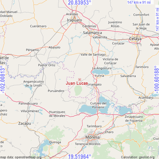
Juan Lucas GPS coordinates[2]
20° 10' 51.528" North, 101° 18' 18" West
| Map corner | latitude | longitude |
|---|---|---|
| Upper-left | 20.83953°, | -102.00813° |
| Center: | 20.18098°, | -101.305° |
| Lower-right: | 19.51964°, | -100.60188° |
| Map W x H: | 146.8×146.8 km | = 91.2×91.2mi |
| max Lat: | 32.7° ⇑39% North |
| Juan Lucas: | 20.18098° |
| min Lat: | ⇓61% South 14.53588° |
| min Long | Juan Lucas | max Long |
| -117.105° | -101.305° | -86.73105° |
| W 24.3%⇐ | ⇒75.7% E |
Elevation
Elevation of Juan Lucas is 1746 m = 5728 ft, and this is 492.3 m = 1615 ft above average elevation for this country.
| Max E: |
3497 m = 11473 ft | 38.9% |
| Juan Lucas | 1746 m 5728 ft | |
| Avg. | 1253.7 m = 4113 ft | |
Min E: |
-1 m = -3 ft | 61.1% |
See also: Mexico elevation on elevation.city.
Geographical zone
Juan Lucas is located in North Torrid zone (between Equator and Tropic of Cancer). Distance of this Northern Tropic circle is 362 km =224.9 mi to North.| Distance of | km | miles | from Juan Lucas |
|---|---|---|---|
| North Pole | 7763.1 | 4823.8 | to North |
| Arctic Circle | 5157.3 | 3204.6 | to North |
| Tropic Cancer | 362 | 224.9 | to North |
| Equator | 2243.9 | 1394.3 | to South |


Nearby cities:
15 places around Juan Lucas: (largest is in red/bold)
• Chamacuero
10.6 km =6.6 mi,  287°
287°
• El Canario
4.2 km =2.6 mi,  230°
230°
• El Moral
5.9 km =3.7 mi,  163°
163°
• El Tigre
7.1 km =4.4 mi,  32°
32°
• Joconoxtle
6.8 km =4.2 mi,  13°
13°
• La Calera
4.4 km =2.7 mi, 233°
• La Ordeña
9.6 km =6 mi, 162°
• Laguna Prieta
6 km =3.7 mi,  312°
312°
• Monte de los Juárez
5.7 km =3.5 mi,  87°
87°
• Ojos de Agua de Cerano
10.3 km =6.4 mi,  218°
218°
• Palo Alto
7.3 km =4.5 mi,  3°
3°
• Providencia de Calera
8.8 km =5.5 mi,  272°
272°
• San Andrés Calera
8.5 km =5.3 mi,  254°
254°
• San Andrés Enguaro
7.3 km =4.5 mi,  77°
77°
• Tejocote de Calera
9.6 km =6 mi, 268°
Sources, notices
• [Note1] Compared only with cities in Mexico existing in our database
• [Src1] Map data: © OpenStreetMap contributors (CC-BY-SA)
• [Src2] Other city data from geonames.org with taken over terms of usage.
• [Src3] Geographical zone / Annual Mean Temperature by Robert A. Rohde @ Wikipedia
