La Ordeña geodata
La Ordeña (Guanajuato) is a populated place; located in Mexico in America/Mexico_City (GMT-6) time zone. With population of 554 people, there are 15392 cities with bigger population in this country. Compared to other cities in Mexico, 59.1% of cities are located further ↓South; 75.5% of cities are located further →East and 74.3% of cities have lower elevation than La Ordeña. Note1


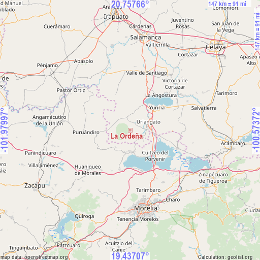
La Ordeña GPS coordinates[2]
20° 5' 55.536" North, 101° 16' 36.624" West
| Map corner | latitude | longitude |
|---|---|---|
| Upper-left | 20.75766°, | -101.97997° |
| Center: | 20.09876°, | -101.27684° |
| Lower-right: | 19.43707°, | -100.57372° |
| Map W x H: | 146.8×146.8 km | = 91.2×91.2mi |
| max Lat: | 32.7° ⇑40.9% North |
| La Ordeña: | 20.09876° |
| min Lat: | ⇓59.1% South 14.53588° |
| min Long | La Ordeña | max Long |
| -117.105° | -101.27684° | -86.73105° |
| W 24.5%⇐ | ⇒75.5% E |
Elevation
Elevation of La Ordeña is 2018 m = 6621 ft, and this is 764.3 m = 2508 ft above average elevation for this country.
| Max E: |
3497 m = 11473 ft | 25.7% |
| La Ordeña | 2018 m 6621 ft | |
| Avg. | 1253.7 m = 4113 ft | |
Min E: |
-1 m = -3 ft | 74.3% |
See also: Mexico elevation on elevation.city.
Geographical zone
La Ordeña is located in North Torrid zone (between Equator and Tropic of Cancer). Distance of this Northern Tropic circle is 371.1 km =230.6 mi to North.| Distance of | km | miles | from La Ordeña |
|---|---|---|---|
| North Pole | 7772.3 | 4829.5 | to North |
| Arctic Circle | 5166.4 | 3210.3 | to North |
| Tropic Cancer | 371.1 | 230.6 | to North |
| Equator | 2234.8 | 1388.6 | to South |


Nearby cities:
15 places around La Ordeña: (largest is in red/bold)
• Cerano
11.6 km =7.2 mi,  275°
275°
• Cerécuaro
9 km =5.6 mi,  233°
233°
• El Canario
8.9 km =5.5 mi,  316°
316°
• El Moral
3.7 km =2.3 mi,  340°
340°
• El Salto
11.2 km =7 mi,  118°
118°
• Huandacareo
11.9 km =7.4 mi,  179°
179°
• Juan Lucas
9.6 km =6 mi, 342°
• La Calera
9.2 km =5.7 mi, 315°
• Monte de los Juárez
9.8 km =6.1 mi,  16°
16°
• Moroleón
9.3 km =5.8 mi,  71°
71°
• Ojos de Agua de Cerano
9.5 km =5.9 mi, 276°
• Piñícuaro
6.8 km =4.2 mi,  146°
146°
• Rinconadas del Bosque
8.3 km =5.2 mi,  100°
100°
• San Andrés Enguaro
11.5 km =7.1 mi, 21°
• Uriangato
10.9 km =6.8 mi,  64°
64°
Sources, notices
• [Note1] Compared only with cities in Mexico existing in our database
• [Src1] Map data: © OpenStreetMap contributors (CC-BY-SA)
• [Src2] Other city data from geonames.org with taken over terms of usage.
• [Src3] Geographical zone / Annual Mean Temperature by Robert A. Rohde @ Wikipedia
