El Moral geodata
El Moral (Guanajuato) is a populated place; located in Mexico in America/Mexico_City (GMT-6) time zone. With population of 1,295 people, there are 6689 cities with bigger population in this country. Compared to other cities in Mexico, 59.8% of cities are located further ↓South; 75.6% of cities are located further →East and 65% of cities have lower elevation than El Moral. Note1


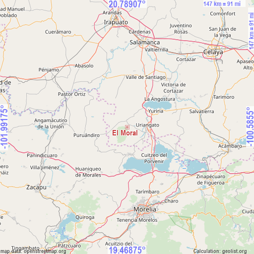
El Moral GPS coordinates[2]
20° 7' 49.08" North, 101° 17' 19.032" West
| Map corner | latitude | longitude |
|---|---|---|
| Upper-left | 20.78907°, | -101.99175° |
| Center: | 20.1303°, | -101.28862° |
| Lower-right: | 19.46875°, | -100.5855° |
| Map W x H: | 146.8×146.8 km | = 91.2×91.2mi |
| max Lat: | 32.7° ⇑40.2% North |
| El Moral: | 20.1303° |
| min Lat: | ⇓59.8% South 14.53588° |
| min Long | El Moral | max Long |
| -117.105° | -101.28862° | -86.73105° |
| W 24.4%⇐ | ⇒75.6% E |
Elevation
Elevation of El Moral is 1830 m = 6004 ft, and this is 576.3 m = 1891 ft above average elevation for this country.
| Max E: |
3497 m = 11473 ft | 35% |
| El Moral | 1830 m 6004 ft | |
| Avg. | 1253.7 m = 4113 ft | |
Min E: |
-1 m = -3 ft | 65% |
See also: Mexico elevation on elevation.city.
Geographical zone
El Moral is located in North Torrid zone (between Equator and Tropic of Cancer). Distance of this Northern Tropic circle is 367.6 km =228.4 mi to North.| Distance of | km | miles | from El Moral |
|---|---|---|---|
| North Pole | 7768.8 | 4827.3 | to North |
| Arctic Circle | 5162.9 | 3208.1 | to North |
| Tropic Cancer | 367.6 | 228.4 | to North |
| Equator | 2238.3 | 1390.8 | to South |


Nearby cities:
15 places around El Moral: (largest is in red/bold)
• Cerano
10.6 km =6.6 mi,  256°
256°
• Cerécuaro
10.7 km =6.6 mi,  213°
213°
• El Canario
5.7 km =3.5 mi,  301°
301°
• Juan Lucas
5.9 km =3.7 mi,  343°
343°
• La Calera
6 km =3.7 mi, 300°
• La Ordeña
3.7 km =2.3 mi,  160°
160°
• Laguna Prieta
11.5 km =7.1 mi,  327°
327°
• Monte de los Juárez
7.1 km =4.4 mi,  33°
33°
• Moroleón
10.1 km =6.3 mi,  92°
92°
• Ojos de Agua de Cerano
8.5 km =5.3 mi,  253°
253°
• Piñícuaro
10.5 km =6.5 mi,  151°
151°
• Rinconadas del Bosque
10.7 km =6.6 mi,  117°
117°
• San Andrés Calera
10.4 km =6.5 mi,  288°
288°
• San Andrés Enguaro
9 km =5.6 mi,  37°
37°
• Uriangato
11.1 km =6.9 mi,  83°
83°
Sources, notices
• [Note1] Compared only with cities in Mexico existing in our database
• [Src1] Map data: © OpenStreetMap contributors (CC-BY-SA)
• [Src2] Other city data from geonames.org with taken over terms of usage.
• [Src3] Geographical zone / Annual Mean Temperature by Robert A. Rohde @ Wikipedia
