Jarillas geodata
Jarillas (Zacatecas) is a populated place; located in Mexico in America/Mexico_City (GMT-6) time zone. With population of 684 people, there are 12694 cities with bigger population in this country. Compared to other cities in Mexico, 86.9% of cities are located further ↓South; 82% of cities are located further →East and 77.8% of cities have lower elevation than Jarillas. Note1


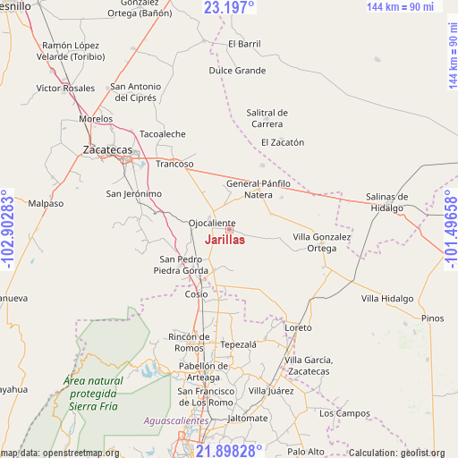
Jarillas GPS coordinates[2]
22° 32' 57.012" North, 102° 11' 58.92" West
| Map corner | latitude | longitude |
|---|---|---|
| Upper-left | 23.197°, | -102.90283° |
| Center: | 22.54917°, | -102.1997° |
| Lower-right: | 21.89828°, | -101.49658° |
| Map W x H: | 144.4×144.4 km | = 89.7×89.7mi |
| max Lat: | 32.7° ⇑13.1% North |
| Jarillas: | 22.54917° |
| min Lat: | ⇓86.9% South 14.53588° |
| min Long | Jarillas | max Long |
| -117.105° | -102.1997° | -86.73105° |
| W 18%⇐ | ⇒82% E |
Elevation
Elevation of Jarillas is 2085 m = 6841 ft, and this is 831.3 m = 2727 ft above average elevation for this country.
| Max E: |
3497 m = 11473 ft | 22.2% |
| Jarillas | 2085 m 6841 ft | |
| Avg. | 1253.7 m = 4113 ft | |
Min E: |
-1 m = -3 ft | 77.8% |
See also: Mexico elevation on elevation.city.
Geographical zone
Jarillas is located in North Torrid zone (between Equator and Tropic of Cancer). Distance of this Northern Tropic circle is 98.7 km =61.3 mi to North.| Distance of | km | miles | from Jarillas |
|---|---|---|---|
| North Pole | 7499.8 | 4660.2 | to North |
| Arctic Circle | 4893.9 | 3040.9 | to North |
| Tropic Cancer | 98.7 | 61.3 | to North |
| Equator | 2507.2 | 1557.9 | to South |


Nearby cities:
15 places around Jarillas: (largest is in red/bold)
• Buenavista
13 km =8.1 mi,  176°
176°
• Colonia Hidalgo
6.2 km =3.9 mi,  220°
220°
• Colonia Veinte de Noviembre
9.9 km =6.2 mi,  238°
238°
• Esteban S. Castorena
11.5 km =7.1 mi,  212°
212°
• La Concepción
7.8 km =4.8 mi, 241°
• Los Griegos
11.3 km =7 mi,  190°
190°
• Luis Moya
13.9 km =8.6 mi,  201°
201°
• Milagros
5.7 km =3.5 mi,  163°
163°
• Pozo de Jarillas
11.5 km =7.1 mi,  0°
0°
• Rancho Nuevo
10.8 km =6.7 mi,  51°
51°
• San Cristóbal
5.8 km =3.6 mi,  322°
322°
• San Pablo
10.3 km =6.4 mi,  83°
83°
• San Ramón
12.1 km =7.5 mi,  33°
33°
• Santa Elena
14 km =8.7 mi,  69°
69°
• Santo Tomás Venaditos (Venaditos)
10.2 km =6.3 mi,  107°
107°
Sources, notices
• [Note1] Compared only with cities in Mexico existing in our database
• [Src1] Map data: © OpenStreetMap contributors (CC-BY-SA)
• [Src2] Other city data from geonames.org with taken over terms of usage.
• [Src3] Geographical zone / Annual Mean Temperature by Robert A. Rohde @ Wikipedia
