Milagros geodata
Milagros (Zacatecas) is a populated place; located in Mexico in America/Mexico_City (GMT-6) time zone. With population of 1,339 people, there are 6495 cities with bigger population in this country. Compared to other cities in Mexico, 86.7% of cities are located further ↓South; 81.9% of cities are located further →East and 80.7% of cities have lower elevation than Milagros. Note1


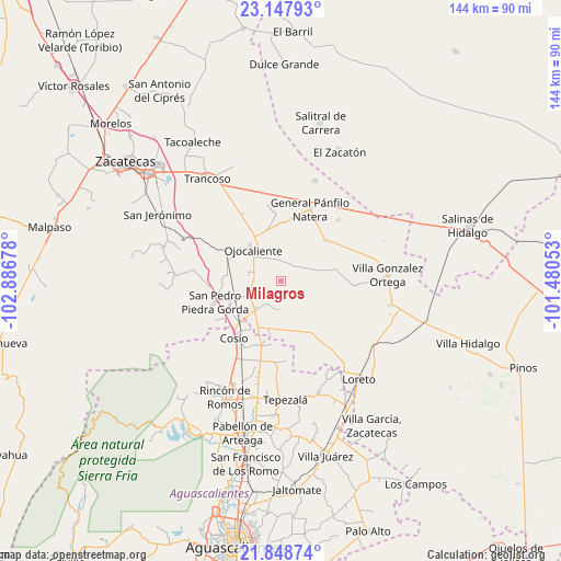
Milagros GPS coordinates[2]
22° 29' 59.496" North, 102° 11' 1.14" West
| Map corner | latitude | longitude |
|---|---|---|
| Upper-left | 23.14793°, | -102.88678° |
| Center: | 22.49986°, | -102.18365° |
| Lower-right: | 21.84874°, | -101.48053° |
| Map W x H: | 144.5×144.5 km | = 89.8×89.8mi |
| max Lat: | 32.7° ⇑13.3% North |
| Milagros: | 22.49986° |
| min Lat: | ⇓86.7% South 14.53588° |
| min Long | Milagros | max Long |
| -117.105° | -102.18365° | -86.73105° |
| W 18.1%⇐ | ⇒81.9% E |
Elevation
Elevation of Milagros is 2158 m = 7080 ft, and this is 904.3 m = 2967 ft above average elevation for this country.
| Max E: |
3497 m = 11473 ft | 19.3% |
| Milagros | 2158 m 7080 ft | |
| Avg. | 1253.7 m = 4113 ft | |
Min E: |
-1 m = -3 ft | 80.7% |
See also: Mexico elevation on elevation.city.
Geographical zone
Milagros is located in North Torrid zone (between Equator and Tropic of Cancer). Distance of this Northern Tropic circle is 104.2 km =64.7 mi to North.| Distance of | km | miles | from Milagros |
|---|---|---|---|
| North Pole | 7505.3 | 4663.6 | to North |
| Arctic Circle | 4899.4 | 3044.3 | to North |
| Tropic Cancer | 104.2 | 64.7 | to North |
| Equator | 2501.7 | 1554.5 | to South |


Nearby cities:
15 places around Milagros: (largest is in red/bold)
• Buenavista
7.6 km =4.7 mi,  186°
186°
• Colonia Hidalgo
5.7 km =3.5 mi,  277°
277°
• Colonia Veinte de Noviembre
10.1 km =6.3 mi,  271°
271°
• Esteban S. Castorena
8.9 km =5.5 mi,  242°
242°
• Jarillas
5.7 km =3.5 mi,  343°
343°
• La Concepción
8.6 km =5.3 mi, 281°
• Los Griegos
6.8 km =4.2 mi,  212°
212°
• Luis Moya
10 km =6.2 mi,  221°
221°
• Pastoría
10.6 km =6.6 mi,  98°
98°
• Rancho Nuevo
14 km =8.7 mi,  29°
29°
• San Cristóbal
11.4 km =7.1 mi,  332°
332°
• San Pablo
10.9 km =6.8 mi,  52°
52°
• Santa María de la Paz
14.6 km =9.1 mi, 211°
• Santo Tomás Venaditos (Venaditos)
8.4 km =5.2 mi,  73°
73°
• Sauceda de Mulatos
11.7 km =7.3 mi,  114°
114°
Sources, notices
• [Note1] Compared only with cities in Mexico existing in our database
• [Src1] Map data: © OpenStreetMap contributors (CC-BY-SA)
• [Src2] Other city data from geonames.org with taken over terms of usage.
• [Src3] Geographical zone / Annual Mean Temperature by Robert A. Rohde @ Wikipedia
