Rancho Nuevo geodata
Rancho Nuevo (Zacatecas) is a populated place; located in Mexico in America/Mexico_City (GMT-6) time zone. With population of 925 people, there are 9432 cities with bigger population in this country. Compared to other cities in Mexico, 87% of cities are located further ↓South; 81.6% of cities are located further →East and 78.5% of cities have lower elevation than Rancho Nuevo. Note1


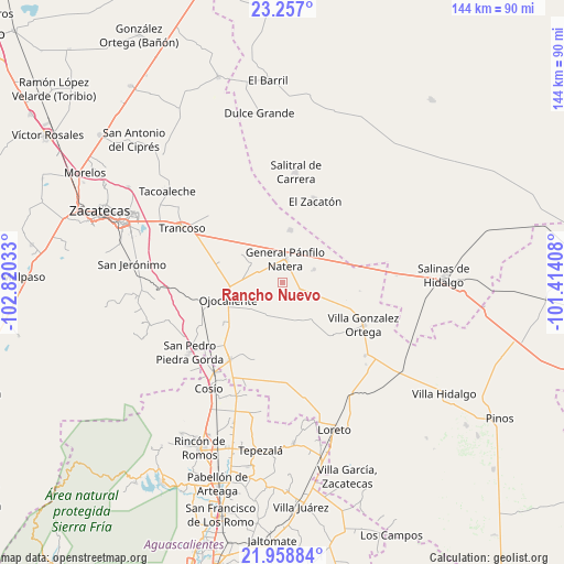
Rancho Nuevo GPS coordinates[2]
22° 36' 34.02" North, 102° 7' 1.92" West
| Map corner | latitude | longitude |
|---|---|---|
| Upper-left | 23.257°, | -102.82033° |
| Center: | 22.60945°, | -102.1172° |
| Lower-right: | 21.95884°, | -101.41408° |
| Map W x H: | 144.3×144.3 km | = 89.7×89.7mi |
| max Lat: | 32.7° ⇑13% North |
| Rancho Nuevo: | 22.60945° |
| min Lat: | ⇓87% South 14.53588° |
| min Long | Rancho Nuevo | max Long |
| -117.105° | -102.1172° | -86.73105° |
| W 18.4%⇐ | ⇒81.6% E |
Elevation
Elevation of Rancho Nuevo is 2100 m = 6890 ft, and this is 846.3 m = 2777 ft above average elevation for this country.
| Max E: |
3497 m = 11473 ft | 21.5% |
| Rancho Nuevo | 2100 m 6890 ft | |
| Avg. | 1253.7 m = 4113 ft | |
Min E: |
-1 m = -3 ft | 78.5% |
See also: Mexico elevation on elevation.city.
Geographical zone
Rancho Nuevo is located in North Torrid zone (between Equator and Tropic of Cancer). Distance of this Northern Tropic circle is 92 km =57.2 mi to North.| Distance of | km | miles | from Rancho Nuevo |
|---|---|---|---|
| North Pole | 7493.1 | 4656 | to North |
| Arctic Circle | 4887.2 | 3036.8 | to North |
| Tropic Cancer | 92 | 57.2 | to North |
| Equator | 2513.9 | 1562.1 | to South |


Nearby cities:
15 places around Rancho Nuevo: (largest is in red/bold)
• Bajío de San Nicolás
12.3 km =7.6 mi,  113°
113°
• El Saucito (El Horno)
13.7 km =8.5 mi,  9°
9°
• El Tule
8.8 km =5.5 mi,  66°
66°
• General Pánfilo Natera
6.2 km =3.9 mi, 6°
• Guanajuatillo
12.2 km =7.6 mi,  347°
347°
• Jarillas
10.8 km =6.7 mi,  231°
231°
• La Tesorera
9.7 km =6 mi,  0°
0°
• Milagros
14 km =8.7 mi,  209°
209°
• Pozo de Jarillas
9.6 km =6 mi,  300°
300°
• San Cristóbal
12.2 km =7.6 mi,  260°
260°
• San José el Saladillo (El Saladillo)
11.7 km =7.3 mi,  44°
44°
• San Pablo
5.8 km =3.6 mi,  162°
162°
• San Ramón
3.8 km =2.4 mi,  331°
331°
• Santa Elena
5.1 km =3.2 mi, 111°
• Santo Tomás Venaditos (Venaditos)
9.9 km =6.2 mi,  173°
173°
Sources, notices
• [Note1] Compared only with cities in Mexico existing in our database
• [Src1] Map data: © OpenStreetMap contributors (CC-BY-SA)
• [Src2] Other city data from geonames.org with taken over terms of usage.
• [Src3] Geographical zone / Annual Mean Temperature by Robert A. Rohde @ Wikipedia
