Ixtla geodata
Ixtla (Guanajuato) is a populated place; located in Mexico in America/Mexico_City (GMT-6) time zone. With population of 985 people, there are 8829 cities with bigger population in this country. Compared to other cities in Mexico, 71% of cities are located further ↓South; 70.2% of cities are located further →East and 67.8% of cities have lower elevation than Ixtla. Note1


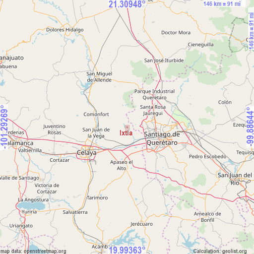
Ixtla GPS coordinates[2]
20° 39' 10.728" North, 100° 35' 22.416" West
| Map corner | latitude | longitude |
|---|---|---|
| Upper-left | 21.30948°, | -101.29269° |
| Center: | 20.65298°, | -100.58956° |
| Lower-right: | 19.99363°, | -99.88644° |
| Map W x H: | 146.3×146.3 km | = 90.9×90.9mi |
| max Lat: | 32.7° ⇑29% North |
| Ixtla: | 20.65298° |
| min Lat: | ⇓71% South 14.53588° |
| min Long | Ixtla | max Long |
| -117.105° | -100.58956° | -86.73105° |
| W 29.8%⇐ | ⇒70.2% E |
Elevation
Elevation of Ixtla is 1884 m = 6181 ft, and this is 630.3 m = 2068 ft above average elevation for this country.
| Max E: |
3497 m = 11473 ft | 32.2% |
| Ixtla | 1884 m 6181 ft | |
| Avg. | 1253.7 m = 4113 ft | |
Min E: |
-1 m = -3 ft | 67.8% |
See also: Mexico elevation on elevation.city.
Geographical zone
Ixtla is located in North Torrid zone (between Equator and Tropic of Cancer). Distance of this Northern Tropic circle is 309.5 km =192.3 mi to North.| Distance of | km | miles | from Ixtla |
|---|---|---|---|
| North Pole | 7710.7 | 4791.2 | to North |
| Arctic Circle | 5104.8 | 3172 | to North |
| Tropic Cancer | 309.5 | 192.3 | to North |
| Equator | 2296.4 | 1426.9 | to South |


Nearby cities:
15 places around Ixtla: (largest is in red/bold)
• Charco de Sierra
8.6 km =5.3 mi,  347°
347°
• El Peñón
6.2 km =3.9 mi,  242°
242°
• El Picacho
8.1 km =5 mi,  322°
322°
• El Zapote
5.6 km =3.5 mi,  91°
91°
• Huertas la Joya [Fraccionamiento Campestre]
9.7 km =6 mi,  110°
110°
• Mompaní
9.6 km =6 mi,  63°
63°
• Obraje de Ixtla
2.7 km =1.7 mi,  312°
312°
• Obrajuelo
7.3 km =4.5 mi,  154°
154°
• Ojo de Agua de Ixtla
3.7 km =2.3 mi,  269°
269°
• Praga
8.3 km =5.2 mi,  77°
77°
• Rancho la Tinaja
7.4 km =4.6 mi,  24°
24°
• San Francisco de la Palma
7.8 km =4.8 mi, 84°
• Tierra Blanca
5.2 km =3.2 mi,  342°
342°
• Tlacote el Alto
7.8 km =4.8 mi, 56°
• Tlacote el Bajo
8.6 km =5.3 mi, 83°
Sources, notices
• [Note1] Compared only with cities in Mexico existing in our database
• [Src1] Map data: © OpenStreetMap contributors (CC-BY-SA)
• [Src2] Other city data from geonames.org with taken over terms of usage.
• [Src3] Geographical zone / Annual Mean Temperature by Robert A. Rohde @ Wikipedia
