El Peñón geodata
El Peñón (Guanajuato) is a populated place; located in Mexico in America/Mexico_City (GMT-6) time zone. With population of 800 people, there are 10908 cities with bigger population in this country. Compared to other cities in Mexico, 70.5% of cities are located further ↓South; 70.7% of cities are located further →East and 69.9% of cities have lower elevation than El Peñón. Note1


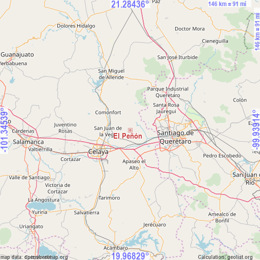
El Peñón GPS coordinates[2]
20° 37' 39.9" North, 100° 38' 32.136" West
| Map corner | latitude | longitude |
|---|---|---|
| Upper-left | 21.28436°, | -101.34539° |
| Center: | 20.62775°, | -100.64226° |
| Lower-right: | 19.96829°, | -99.93914° |
| Map W x H: | 146.3×146.3 km | = 90.9×90.9mi |
| max Lat: | 32.7° ⇑29.5% North |
| El Peñón: | 20.62775° |
| min Lat: | ⇓70.5% South 14.53588° |
| min Long | El Peñón | max Long |
| -117.105° | -100.64226° | -86.73105° |
| W 29.3%⇐ | ⇒70.7% E |
Elevation
Elevation of El Peñón is 1921 m = 6302 ft, and this is 667.3 m = 2189 ft above average elevation for this country.
| Max E: |
3497 m = 11473 ft | 30.1% |
| El Peñón | 1921 m 6302 ft | |
| Avg. | 1253.7 m = 4113 ft | |
Min E: |
-1 m = -3 ft | 69.9% |
See also: Mexico elevation on elevation.city.
Geographical zone
El Peñón is located in North Torrid zone (between Equator and Tropic of Cancer). Distance of this Northern Tropic circle is 312.3 km =194.1 mi to North.| Distance of | km | miles | from El Peñón |
|---|---|---|---|
| North Pole | 7713.5 | 4792.9 | to North |
| Arctic Circle | 5107.6 | 3173.7 | to North |
| Tropic Cancer | 312.3 | 194.1 | to North |
| Equator | 2293.6 | 1425.2 | to South |


Nearby cities:
15 places around El Peñón: (largest is in red/bold)
• Coachiti
9.4 km =5.8 mi,  144°
144°
• El Picacho
9.2 km =5.7 mi,  3°
3°
• El Tunal
6.9 km =4.3 mi,  160°
160°
• El Vicarlo
5.9 km =3.7 mi,  210°
210°
• Galvanes
7.5 km =4.7 mi,  288°
288°
• Guadalupe del Monte
7.9 km =4.9 mi,  178°
178°
• Ixtla
6.2 km =3.9 mi,  62°
62°
• Jauregui
8.9 km =5.5 mi,  244°
244°
• Jocoqui
7.8 km =4.8 mi,  229°
229°
• Obraje de Ixtla
5.8 km =3.6 mi,  37°
37°
• Obrajuelo
9.4 km =5.8 mi,  113°
113°
• Ojo de Agua de Ixtla
3.3 km =2.1 mi,  33°
33°
• San José Viborillas
6.7 km =4.2 mi,  172°
172°
• San Ramón
9.9 km =6.2 mi,  224°
224°
• Tierra Blanca
8.7 km =5.4 mi, 26°
Sources, notices
• [Note1] Compared only with cities in Mexico existing in our database
• [Src1] Map data: © OpenStreetMap contributors (CC-BY-SA)
• [Src2] Other city data from geonames.org with taken over terms of usage.
• [Src3] Geographical zone / Annual Mean Temperature by Robert A. Rohde @ Wikipedia
