Coruña geodata
Coruña (Coahuila) is a populated place; located in Mexico in America/Monterrey (GMT-6) time zone. With population of 978 people, there are 8889 cities with bigger population in this country. Compared to other cities in Mexico, 94.8% of cities are located further ↓South; 87.1% of cities are located further →East and 58% of cities have higher elevation than Coruña. Note1


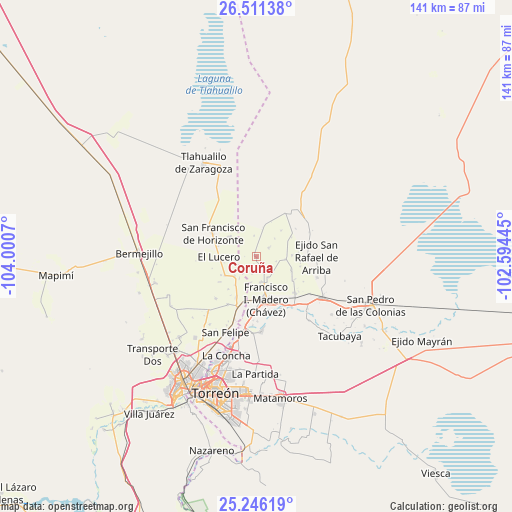
Coruña GPS coordinates[2]
25° 52' 49.728" North, 103° 17' 51.252" West
| Map corner | latitude | longitude |
|---|---|---|
| Upper-left | 26.51138°, | -104.0007° |
| Center: | 25.88048°, | -103.29757° |
| Lower-right: | 25.24619°, | -102.59445° |
| Map W x H: | 140.7×140.7 km | = 87.4×87.4mi |
| max Lat: | 32.7° ⇑5.2% North |
| Coruña: | 25.88048° |
| min Lat: | ⇓94.8% South 14.53588° |
| min Long | Coruña | max Long |
| -117.105° | -103.29757° | -86.73105° |
| W 12.9%⇐ | ⇒87.1% E |
Elevation
Elevation of Coruña is 1102 m = 3615 ft, and this is 151.7 m = 498 ft below average elevation for this country.
| Max E: |
3497 m = 11473 ft | 58% |
| Avg. | 1253.7 m = 4113 ft | |
| Coruña | 1102 m = 3615 ft | |
Min E: |
-1 m = -3 ft | 42% |
See also: Mexico elevation on elevation.city.
Geographical zone
Coruña is located in North temperate zone (between Tropic of Cancer and the Arctic Circle). Distance of this Northern Tropic circle is 271.7 km =168.8 mi to South.| Distance of | km | miles | from Coruña |
|---|---|---|---|
| North Pole | 7129.4 | 4430 | to North |
| Arctic Circle | 4523.5 | 2810.8 | to North |
| Tropic Cancer | 271.7 | 168.8 | to South |
| Equator | 2877.6 | 1788.1 | to South |


Nearby cities:
15 places around Coruña: (largest is in red/bold)
• Banco Nacional
6 km =3.7 mi,  260°
260°
• Colón
4.6 km =2.9 mi,  139°
139°
• Covadonga
7 km =4.3 mi,  45°
45°
• El Lequeitio
4.2 km =2.6 mi,  153°
153°
• Florencia
4.8 km =3 mi,  194°
194°
• Hidalgo
7.3 km =4.5 mi,  168°
168°
• Huitrón
5.7 km =3.5 mi,  243°
243°
• Jauja
9.3 km =5.8 mi,  305°
305°
• Jiménez
8.2 km =5.1 mi,  227°
227°
• La Pinta
4.1 km =2.5 mi, 52°
• Las Mercedes
4.6 km =2.9 mi,  179°
179°
• San Alberto
7.6 km =4.7 mi,  218°
218°
• San José de la Niña
8 km =5 mi,  94°
94°
• Santa María
5.6 km =3.5 mi,  104°
104°
• Virginias
9.2 km =5.7 mi,  164°
164°
Sources, notices
• [Note1] Compared only with cities in Mexico existing in our database
• [Src1] Map data: © OpenStreetMap contributors (CC-BY-SA)
• [Src2] Other city data from geonames.org with taken over terms of usage.
• [Src3] Geographical zone / Annual Mean Temperature by Robert A. Rohde @ Wikipedia
