Huajicori geodata
Huajicori (Nayarit) is a populated place; located in Mexico in America/Mazatlan (GMT-7) time zone. With population of 3,004 people, there are 2991 cities with bigger population in this country. Compared to other cities in Mexico, 87.1% of cities are located further ↓South; 92.8% of cities are located further →East and 81.7% of cities have higher elevation than Huajicori. Note1


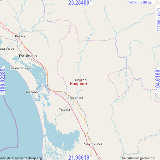
Huajicori GPS coordinates[2]
22° 38' 12.012" North, 105° 19' 10.992" West
| Map corner | latitude | longitude |
|---|---|---|
| Upper-left | 23.28409°, | -106.02285° |
| Center: | 22.63667°, | -105.31972° |
| Lower-right: | 21.98619°, | -104.6166° |
| Map W x H: | 144.3×144.3 km | = 89.7×89.7mi |
| max Lat: | 32.7° ⇑12.9% North |
| Huajicori: | 22.63667° |
| min Lat: | ⇓87.1% South 14.53588° |
| min Long | Huajicori | max Long |
| -117.105° | -105.31972° | -86.73105° |
| W 7.2%⇐ | ⇒92.8% E |
Elevation
Elevation of Huajicori is 73 m = 240 ft, and this is 1180.7 m = 3874 ft below average elevation for this country.
| Max E: |
3497 m = 11473 ft | 81.7% |
| Avg. | 1253.7 m = 4113 ft | |
| Huajicori | 73 m = 240 ft | |
Min E: |
-1 m = -3 ft | 18.3% |
See also: Mexico elevation on elevation.city.
Geographical zone
Huajicori is located in North Torrid zone (between Equator and Tropic of Cancer). Distance of this Northern Tropic circle is 89 km =55.3 mi to North.| Distance of | km | miles | from Huajicori |
|---|---|---|---|
| North Pole | 7490.1 | 4654.1 | to North |
| Arctic Circle | 4884.2 | 3034.9 | to North |
| Tropic Cancer | 89 | 55.3 | to North |
| Equator | 2517 | 1564 | to South |


Nearby cities:
15 places around Huajicori: (largest is in red/bold)
• Acaponeta
16.5 km =10.3 mi,  195°
195°
• Camalotita
28.3 km =17.6 mi, 203°
• El Aguaje
25 km =15.5 mi,  233°
233°
• El Centenario
14.7 km =9.1 mi, 198°
• El Recodo
13 km =8.1 mi,  190°
190°
• El Resbalón
27 km =16.8 mi,  176°
176°
• El Tigre
21.5 km =13.4 mi,  224°
224°
• La Concha (La Concepción)
17.9 km =11.1 mi, 229°
• La Guásima
26.6 km =16.5 mi, 195°
• Llano de la Cruz
23.2 km =14.4 mi, 194°
• Ojo de Agua de Palmillas
29.2 km =18.1 mi,  266°
266°
• Pajaritos
29.3 km =18.2 mi, 226°
• San Felipe Aztatán
29.9 km =18.6 mi, 200°
• San José de Gracia
18.3 km =11.4 mi, 199°
• Sayulilla
23.3 km =14.5 mi, 198°
Sources, notices
• [Note1] Compared only with cities in Mexico existing in our database
• [Src1] Map data: © OpenStreetMap contributors (CC-BY-SA)
• [Src2] Other city data from geonames.org with taken over terms of usage.
• [Src3] Geographical zone / Annual Mean Temperature by Robert A. Rohde @ Wikipedia
