Guasavito geodata
Guasavito (Sinaloa) is a populated place; located in Mexico in America/Mazatlan (GMT-7) time zone. With population of 1,721 people, there are 5042 cities with bigger population in this country. Compared to other cities in Mexico, 92.9% of cities are located further ↓South; 96.2% of cities are located further →East and 90.8% of cities have higher elevation than Guasavito. Note1


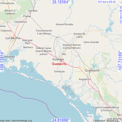
Guasavito GPS coordinates[2]
25° 33' 10.728" North, 108° 26' 6.036" West
| Map corner | latitude | longitude |
|---|---|---|
| Upper-left | 26.18564°, | -109.13814° |
| Center: | 25.55298°, | -108.43501° |
| Lower-right: | 24.91696°, | -107.73189° |
| Map W x H: | 141.1×141.1 km | = 87.7×87.7mi |
| max Lat: | 32.7° ⇑7.1% North |
| Guasavito: | 25.55298° |
| min Lat: | ⇓92.9% South 14.53588° |
| min Long | Guasavito | max Long |
| -117.105° | -108.43501° | -86.73105° |
| W 3.8%⇐ | ⇒96.2% E |
Elevation
Elevation of Guasavito is 22 m = 72 ft, and this is 1231.7 m = 4041 ft below average elevation for this country.
| Max E: |
3497 m = 11473 ft | 90.8% |
| Avg. | 1253.7 m = 4113 ft | |
| Guasavito | 22 m = 72 ft | |
Min E: |
-1 m = -3 ft | 9.2% |
See also: Mexico elevation on elevation.city.
Geographical zone
Guasavito is located in North temperate zone (between Tropic of Cancer and the Arctic Circle). Distance of this Northern Tropic circle is 235.3 km =146.2 mi to South.| Distance of | km | miles | from Guasavito |
|---|---|---|---|
| North Pole | 7165.8 | 4452.6 | to North |
| Arctic Circle | 4559.9 | 2833.4 | to North |
| Tropic Cancer | 235.3 | 146.2 | to South |
| Equator | 2841.2 | 1765.4 | to South |


Nearby cities:
15 places around Guasavito: (largest is in red/bold)
• Caimanero
5.9 km =3.7 mi,  352°
352°
• Chorohui
4.9 km =3 mi,  213°
213°
• El Burrión
2.7 km =1.7 mi,  125°
125°
• El Cuitabón
7.4 km =4.6 mi,  0°
0°
• El Nio
8.7 km =5.4 mi,  23°
23°
• Guasave
3.6 km =2.2 mi,  296°
296°
• La Sabanilla (Campo Preciado)
7.6 km =4.7 mi,  273°
273°
• Ladrilleras de Ocoro
5.2 km =3.2 mi,  343°
343°
• Las Crucecitas
3.1 km =1.9 mi, 354°
• Los Angeles
7.2 km =4.5 mi,  320°
320°
• Pueblo Viejo
7.1 km =4.4 mi, 15°
• Ranchito de Castro
4.2 km =2.6 mi, 24°
• San Gabriel
4.8 km =3 mi,  237°
237°
• San Pedro Guasave
2.7 km =1.7 mi,  232°
232°
• San Pedro Paredes
2.3 km =1.4 mi,  192°
192°
Sources, notices
• [Note1] Compared only with cities in Mexico existing in our database
• [Src1] Map data: © OpenStreetMap contributors (CC-BY-SA)
• [Src2] Other city data from geonames.org with taken over terms of usage.
• [Src3] Geographical zone / Annual Mean Temperature by Robert A. Rohde @ Wikipedia
