Vicente Guerrero geodata
Vicente Guerrero (Durango) is a seat of a second-order administrative division; located in Mexico in America/Monterrey (GMT-6) time zone. With population of 15,982 people, there are 603 cities with bigger population in this country. Compared to other cities in Mexico, 89.3% of cities are located further ↓South; 89.9% of cities are located further →East and 70.1% of cities have lower elevation than Vicente Guerrero. Note1


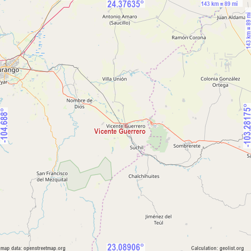
Vicente Guerrero GPS coordinates[2]
23° 44' 3.444" North, 103° 59' 5.532" West
| Map corner | latitude | longitude |
|---|---|---|
| Upper-left | 24.37635°, | -104.688° |
| Center: | 23.73429°, | -103.98487° |
| Lower-right: | 23.08906°, | -103.28175° |
| Map W x H: | 143.1×143.1 km | = 88.9×88.9mi |
| max Lat: | 32.7° ⇑10.7% North |
| Vicente Guerrero: | 23.73429° |
| min Lat: | ⇓89.3% South 14.53588° |
| min Long | Vicente Guerrer | max Long |
| -117.105° | -103.98487° | -86.73105° |
| W 10.1%⇐ | ⇒89.9% E |
Elevation
Elevation of Vicente Guerrero is 1925 m = 6316 ft, and this is 671.3 m = 2202 ft above average elevation for this country.
| Max E: |
3497 m = 11473 ft | 29.9% |
| Vicente Guerrero | 1925 m 6316 ft | |
| Avg. | 1253.7 m = 4113 ft | |
Min E: |
-1 m = -3 ft | 70.1% |
See also: Mexico elevation on elevation.city.
Geographical zone
Vicente Guerrero is located in North temperate zone (between Tropic of Cancer and the Arctic Circle). Distance of this Northern Tropic circle is 33.1 km =20.6 mi to South.| Distance of | km | miles | from Vicente Guerrero |
|---|---|---|---|
| North Pole | 7368.1 | 4578.3 | to North |
| Arctic Circle | 4762.2 | 2959.1 | to North |
| Tropic Cancer | 33.1 | 20.6 | to South |
| Equator | 2639 | 1639.8 | to South |


Nearby cities:
15 places around Vicente Guerrero: (largest is in red/bold)
• Agua Zarca
25.6 km =15.9 mi,  64°
64°
• Amado Nervo
23.8 km =14.8 mi,  300°
300°
• Gabriel Hernández (Mancinas)
9.5 km =5.9 mi,  334°
334°
• Graseros
5.8 km =3.6 mi,  276°
276°
• Gualterio
21.1 km =13.1 mi,  142°
142°
• La Joya
11.6 km =7.2 mi,  353°
353°
• Orizaba
26.4 km =16.4 mi,  339°
339°
• Rojas
15.2 km =9.4 mi, 331°
• San Francisco Javier
5.1 km =3.2 mi,  259°
259°
• San Isidro de Murillos
9.6 km =6 mi,  220°
220°
• San José de Félix
24.4 km =15.2 mi,  93°
93°
• San Martin
24.9 km =15.5 mi,  106°
106°
• Santa Cruz de Guadalupe
23.6 km =14.7 mi, 303°
• Súchil
14 km =8.7 mi,  153°
153°
• Villa Insurgentes (El Calabazal)
14.5 km =9 mi, 86°
Sources, notices
• [Note1] Compared only with cities in Mexico existing in our database
• [Src1] Map data: © OpenStreetMap contributors (CC-BY-SA)
• [Src2] Other city data from geonames.org with taken over terms of usage.
• [Src3] Geographical zone / Annual Mean Temperature by Robert A. Rohde @ Wikipedia
