Galvanes geodata
Galvanes (Guanajuato) is a populated place; located in Mexico in America/Mexico_City (GMT-6) time zone. With population of 715 people, there are 12184 cities with bigger population in this country. Compared to other cities in Mexico, 70.9% of cities are located further ↓South; 71.1% of cities are located further →East and 66.8% of cities have lower elevation than Galvanes. Note1


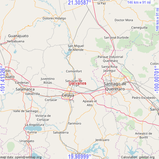
Galvanes GPS coordinates[2]
20° 38' 57.66" North, 100° 42' 36.468" West
| Map corner | latitude | longitude |
|---|---|---|
| Upper-left | 21.30587°, | -101.41326° |
| Center: | 20.64935°, | -100.71013° |
| Lower-right: | 19.98999°, | -100.00701° |
| Map W x H: | 146.3×146.3 km | = 90.9×90.9mi |
| max Lat: | 32.7° ⇑29.1% North |
| Galvanes: | 20.64935° |
| min Lat: | ⇓70.9% South 14.53588° |
| min Long | Galvanes | max Long |
| -117.105° | -100.71013° | -86.73105° |
| W 28.9%⇐ | ⇒71.1% E |
Elevation
Elevation of Galvanes is 1865 m = 6119 ft, and this is 611.3 m = 2006 ft above average elevation for this country.
| Max E: |
3497 m = 11473 ft | 33.2% |
| Galvanes | 1865 m 6119 ft | |
| Avg. | 1253.7 m = 4113 ft | |
Min E: |
-1 m = -3 ft | 66.8% |
See also: Mexico elevation on elevation.city.
Geographical zone
Galvanes is located in North Torrid zone (between Equator and Tropic of Cancer). Distance of this Northern Tropic circle is 309.9 km =192.6 mi to North.| Distance of | km | miles | from Galvanes |
|---|---|---|---|
| North Pole | 7711.1 | 4791.5 | to North |
| Arctic Circle | 5105.2 | 3172.2 | to North |
| Tropic Cancer | 309.9 | 192.6 | to North |
| Equator | 2296 | 1426.7 | to South |


Nearby cities:
15 places around Galvanes: (largest is in red/bold)
• El Peñón
7.5 km =4.7 mi,  108°
108°
• El Vicarlo
8.5 km =5.3 mi,  151°
151°
• Empalme Escobedo
4.6 km =2.9 mi,  304°
304°
• Guadalupe
4 km =2.5 mi,  277°
277°
• Jauregui
6.4 km =4 mi,  188°
188°
• Jocoqui
7.6 km =4.7 mi,  170°
170°
• La Aurora
5.5 km =3.4 mi,  242°
242°
• Ojo de Agua de Ixtla
8.9 km =5.5 mi,  87°
87°
• Presa Blanca
8.6 km =5.3 mi,  264°
264°
• San Antonio Espinoza
9 km =5.6 mi,  272°
272°
• San Antonio Gallardo
6.4 km =4 mi,  248°
248°
• San Isidro (La Loma)
9 km =5.6 mi,  310°
310°
• San Isidro de la Concepción
8.2 km =5.1 mi, 253°
• San José de la Presa
6.1 km =3.8 mi,  225°
225°
• San Juan de la Vega
6 km =3.7 mi, 243°
Sources, notices
• [Note1] Compared only with cities in Mexico existing in our database
• [Src1] Map data: © OpenStreetMap contributors (CC-BY-SA)
• [Src2] Other city data from geonames.org with taken over terms of usage.
• [Src3] Geographical zone / Annual Mean Temperature by Robert A. Rohde @ Wikipedia
