Rancho Nuevo geodata
Rancho Nuevo (Nayarit) is a populated place; located in Mexico in America/Mazatlan (GMT-7) time zone. With population of 809 people, there are 10801 cities with bigger population in this country. Compared to other cities in Mexico, 83.5% of cities are located further ↓South; 93.4% of cities are located further →East and 99.6% of cities have higher elevation than Rancho Nuevo. Note1


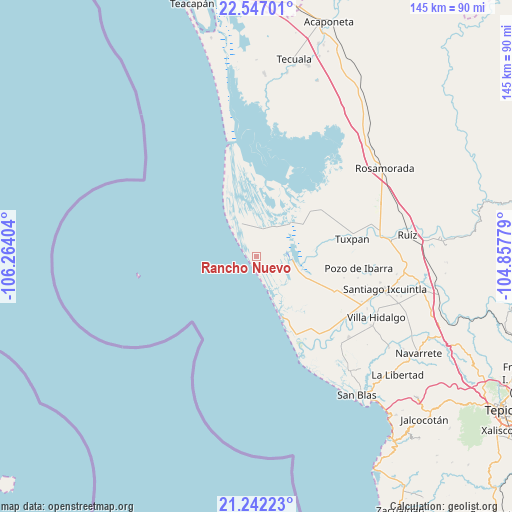
Rancho Nuevo GPS coordinates[2]
21° 53' 45.996" North, 105° 33' 39.276" West
| Map corner | latitude | longitude |
|---|---|---|
| Upper-left | 22.54701°, | -106.26404° |
| Center: | 21.89611°, | -105.56091° |
| Lower-right: | 21.24223°, | -104.85779° |
| Map W x H: | 145.1×145.1 km | = 90.2×90.2mi |
| max Lat: | 32.7° ⇑16.5% North |
| Rancho Nuevo: | 21.89611° |
| min Lat: | ⇓83.5% South 14.53588° |
| min Long | Rancho Nuevo | max Long |
| -117.105° | -105.56091° | -86.73105° |
| W 6.6%⇐ | ⇒93.4% E |
Elevation
Elevation of Rancho Nuevo is 4 m = 13 ft, and this is 1249.7 m = 4100 ft below average elevation for this country.
| Max E: |
3497 m = 11473 ft | 99.6% |
| Avg. | 1253.7 m = 4113 ft | |
| Rancho Nuevo | 4 m = 13 ft | |
Min E: |
-1 m = -3 ft | 0.4% |
See also: Mexico elevation on elevation.city.
Geographical zone
Rancho Nuevo is located in North Torrid zone (between Equator and Tropic of Cancer). Distance of this Northern Tropic circle is 171.3 km =106.4 mi to North.| Distance of | km | miles | from Rancho Nuevo |
|---|---|---|---|
| North Pole | 7572.4 | 4705.3 | to North |
| Arctic Circle | 4966.6 | 3086.1 | to North |
| Tropic Cancer | 171.3 | 106.4 | to North |
| Equator | 2434.6 | 1512.8 | to South |


Nearby cities:
15 places around Rancho Nuevo: (largest is in red/bold)
• Campos de los Limones
17.9 km =11.1 mi,  124°
124°
• El Limón
25.5 km =15.8 mi,  103°
103°
• La Boquita
25.3 km =15.7 mi,  62°
62°
• La Higuerita
1.8 km =1.1 mi,  74°
74°
• Los Corchos
20.1 km =12.5 mi,  153°
153°
• Los Medina
24.2 km =15 mi, 60°
• Mayorquín
1.2 km =0.7 mi,  341°
341°
• Palma Grande
20.7 km =12.9 mi, 58°
• Puerta de Palapares
24.1 km =15 mi, 342°
• San Andrés
2.3 km =1.4 mi,  331°
331°
• San Miguel Número Dos (El Quemado)
19.1 km =11.9 mi,  113°
113°
• Santa Cruz
10.4 km =6.5 mi, 336°
• Sentispac
24.4 km =15.2 mi, 114°
• Unión de Corrientes
16.2 km =10.1 mi, 56°
• Vicente Guerrero (El Mogote)
22.2 km =13.8 mi, 57°
Sources, notices
• [Note1] Compared only with cities in Mexico existing in our database
• [Src1] Map data: © OpenStreetMap contributors (CC-BY-SA)
• [Src2] Other city data from geonames.org with taken over terms of usage.
• [Src3] Geographical zone / Annual Mean Temperature by Robert A. Rohde @ Wikipedia
