Vicente Guerrero (El Mogote) geodata
Vicente Guerrero (El Mogote) (Nayarit) is a populated place; located in Mexico in America/Mazatlan (GMT-7) time zone. With population of 630 people, there are 13737 cities with bigger population in this country. Compared to other cities in Mexico, 84.2% of cities are located further ↓South; 93% of cities are located further →East and 98.7% of cities have higher elevation than Vicente Guerrero (El Mogote). Note1
Current local time in Vicente Guerrero (El Mogote):
07:28 AM, WednesdayDifference from your time zone: hours


Vicente Guerrero (El Mogote) GPS coordinates[2]
22° 0' 10.008" North, 105° 22' 45.984" West
| Map corner | latitude | longitude |
|---|---|---|
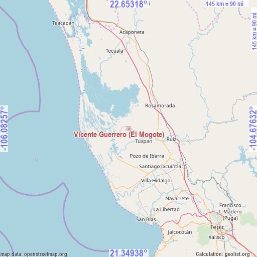
| Upper-left | 22.65318°, | -106.08257° |
| Center: | 22.00278°, | -105.37944° |
| Lower-right: | 21.34938°, | -104.67632° |
| Map W x H: | 145×145 km | = 90.1×90.1mi |
| max Lat: | 32.7° ⇑15.8% North |
| Vicente Guerrero (El Mogote): | 22.00278° |
| min Lat: | ⇓84.2% South 14.53588° |
| min Long | Vicente Guerrer | max Long |
| -117.105° | -105.37944° | -86.73105° |
| W 7%⇐ | ⇒93% E |
Elevation
Elevation of Vicente Guerrero (El Mogote) is 7 m = 23 ft, and this is 1246.7 m = 4090 ft below average elevation for this country.
| Max E: |
3497 m = 11473 ft | 98.7% |
| Avg. | 1253.7 m = 4113 ft | |
| Vicente Guerrero (El Mogote) | 7 m = 23 ft | |
Min E: |
-1 m = -3 ft | 1.3% |
See also: Mexico elevation on elevation.city.
Geographical zone
Vicente Guerrero (El Mogote) is located in North Torrid zone (between Equator and Tropic of Cancer). Distance of this Northern Tropic circle is 159.4 km =99 mi to North.| Distance of | km | miles | from Vicente Guerrero (El Mogote) |
|---|---|---|---|
| North Pole | 7560.6 | 4697.9 | to North |
| Arctic Circle | 4954.7 | 3078.7 | to North |
| Tropic Cancer | 159.4 | 99 | to North |
| Equator | 2446.5 | 1520.2 | to South |


Nearby cities:
15 places around Vicente Guerrero (El Mogote): (largest is in red/bold)
• Chilapa
15.7 km =9.8 mi,  78°
78°
• Cuamiles
15.7 km =9.8 mi,  124°
124°
• El Limón
18.9 km =11.7 mi,  161°
161°
• El Tamarindo
16 km =9.9 mi,  108°
108°
• La Boquita
3.8 km =2.4 mi,  95°
95°
• Llano del Tigre
15.8 km =9.8 mi,  28°
28°
• Los Medina
2.3 km =1.4 mi,  88°
88°
• Palma Grande
1.5 km =0.9 mi,  224°
224°
• Paso Real del Bejuco
19.9 km =12.4 mi, 84°
• Pericos
5.8 km =3.6 mi, 26°
• Pozo de Ibarra
18.3 km =11.4 mi,  145°
145°
• San Miguel Número Dos (El Quemado)
19.4 km =12.1 mi,  183°
183°
• San Vicente
10.3 km =6.4 mi, 124°
• Tuxpan
10.7 km =6.6 mi,  128°
128°
• Unión de Corrientes
6 km =3.7 mi,  240°
240°
Sources, notices
• [Note1] Compared only with cities in Mexico existing in our database
• [Src1] Map data: © OpenStreetMap contributors (CC-BY-SA)
• [Src2] Other city data from geonames.org with taken over terms of usage.
• [Src3] Geographical zone / Annual Mean Temperature by Robert A. Rohde @ Wikipedia
