Palma Grande geodata
Palma Grande (Nayarit) is a populated place; located in Mexico in America/Mazatlan (GMT-7) time zone. With population of 2,399 people, there are 3679 cities with bigger population in this country. Compared to other cities in Mexico, 84.2% of cities are located further ↓South; 93% of cities are located further →East and 98.7% of cities have higher elevation than Palma Grande. Note1


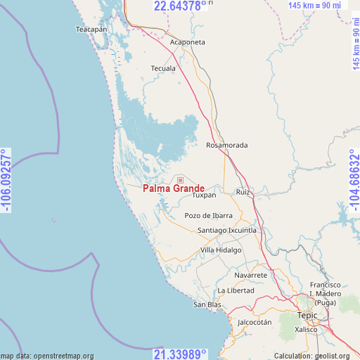
Palma Grande GPS coordinates[2]
21° 59' 35.988" North, 105° 23' 21.984" West
| Map corner | latitude | longitude |
|---|---|---|
| Upper-left | 22.64378°, | -106.09257° |
| Center: | 21.99333°, | -105.38944° |
| Lower-right: | 21.33989°, | -104.68632° |
| Map W x H: | 145×145 km | = 90.1×90.1mi |
| max Lat: | 32.7° ⇑15.8% North |
| Palma Grande: | 21.99333° |
| min Lat: | ⇓84.2% South 14.53588° |
| min Long | Palma Grande | max Long |
| -117.105° | -105.38944° | -86.73105° |
| W 7%⇐ | ⇒93% E |
Elevation
Elevation of Palma Grande is 7 m = 23 ft, and this is 1246.7 m = 4090 ft below average elevation for this country.
| Max E: |
3497 m = 11473 ft | 98.7% |
| Avg. | 1253.7 m = 4113 ft | |
| Palma Grande | 7 m = 23 ft | |
Min E: |
-1 m = -3 ft | 1.3% |
See also: Mexico elevation on elevation.city.
Geographical zone
Palma Grande is located in North Torrid zone (between Equator and Tropic of Cancer). Distance of this Northern Tropic circle is 160.5 km =99.7 mi to North.| Distance of | km | miles | from Palma Grande |
|---|---|---|---|
| North Pole | 7561.6 | 4698.6 | to North |
| Arctic Circle | 4955.7 | 3079.3 | to North |
| Tropic Cancer | 160.5 | 99.7 | to North |
| Equator | 2445.4 | 1519.5 | to South |


Nearby cities:
15 places around Palma Grande: (largest is in red/bold)
• Chilapa
16.9 km =10.5 mi,  75°
75°
• Cuamiles
16 km =9.9 mi,  119°
119°
• El Limón
18.3 km =11.4 mi,  157°
157°
• El Tamarindo
16.7 km =10.4 mi,  103°
103°
• La Boquita
4.9 km =3 mi, 81°
• La Higuerita
19 km =11.8 mi,  237°
237°
• Llano del Tigre
17.2 km =10.7 mi,  30°
30°
• Los Medina
3.5 km =2.2 mi,  71°
71°
• Pericos
7.2 km =4.5 mi, 30°
• Pozo de Ibarra
18.1 km =11.2 mi,  141°
141°
• San Miguel Número Dos (El Quemado)
18.3 km =11.4 mi,  180°
180°
• San Vicente
10.6 km =6.6 mi, 116°
• Tuxpan
10.9 km =6.8 mi, 121°
• Unión de Corrientes
4.6 km =2.9 mi,  245°
245°
• Vicente Guerrero (El Mogote)
1.5 km =0.9 mi,  44°
44°
Sources, notices
• [Note1] Compared only with cities in Mexico existing in our database
• [Src1] Map data: © OpenStreetMap contributors (CC-BY-SA)
• [Src2] Other city data from geonames.org with taken over terms of usage.
• [Src3] Geographical zone / Annual Mean Temperature by Robert A. Rohde @ Wikipedia
