El Limón geodata
El Limón (Nayarit) is a populated place; located in Mexico in America/Mazatlan (GMT-7) time zone. With population of 711 people, there are 12248 cities with bigger population in this country. Compared to other cities in Mexico, 83.2% of cities are located further ↓South; 92.8% of cities are located further →East and 96.3% of cities have higher elevation than El Limón. Note1


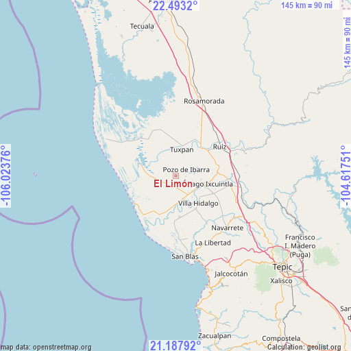
El Limón GPS coordinates[2]
21° 50' 31.38" North, 105° 19' 14.268" West
| Map corner | latitude | longitude |
|---|---|---|
| Upper-left | 22.4932°, | -106.02376° |
| Center: | 21.84205°, | -105.32063° |
| Lower-right: | 21.18792°, | -104.61751° |
| Map W x H: | 145.1×145.1 km | = 90.2×90.2mi |
| max Lat: | 32.7° ⇑16.8% North |
| El Limón: | 21.84205° |
| min Lat: | ⇓83.2% South 14.53588° |
| min Long | El Limón | max Long |
| -117.105° | -105.32063° | -86.73105° |
| W 7.2%⇐ | ⇒92.8% E |
Elevation
Elevation of El Limón is 11 m = 36 ft, and this is 1242.7 m = 4077 ft below average elevation for this country.
| Max E: |
3497 m = 11473 ft | 96.3% |
| Avg. | 1253.7 m = 4113 ft | |
| El Limón | 11 m = 36 ft | |
Min E: |
-1 m = -3 ft | 3.7% |
See also: Mexico elevation on elevation.city.
Geographical zone
El Limón is located in North Torrid zone (between Equator and Tropic of Cancer). Distance of this Northern Tropic circle is 177.3 km =110.2 mi to North.| Distance of | km | miles | from El Limón |
|---|---|---|---|
| North Pole | 7578.5 | 4709.1 | to North |
| Arctic Circle | 4972.6 | 3089.8 | to North |
| Tropic Cancer | 177.3 | 110.2 | to North |
| Equator | 2428.6 | 1509.1 | to South |


Nearby cities:
15 places around El Limón: (largest is in red/bold)
• Amapa
9.4 km =5.8 mi,  133°
133°
• Campos de los Limones
11 km =6.8 mi,  247°
247°
• Cerritos
8.4 km =5.2 mi,  143°
143°
• Colonia Emiliano Zapata
10.5 km =6.5 mi,  98°
98°
• Cuamiles
11.4 km =7.1 mi,  37°
37°
• El Botadero
10.4 km =6.5 mi,  160°
160°
• El Puente
7.7 km =4.8 mi,  83°
83°
• Gavilán Grande
5.6 km =3.5 mi,  149°
149°
• Pozo de Ibarra
5.1 km =3.2 mi,  56°
56°
• Pozo de Villa
2 km =1.2 mi,  123°
123°
• Pueblo Nuevo
7.9 km =4.9 mi,  171°
171°
• San Miguel Número Dos (El Quemado)
7.4 km =4.6 mi,  258°
258°
• Sentispac
4.9 km =3 mi,  212°
212°
• Tuxpan
11.4 km =7.1 mi,  11°
11°
• Valle Morelos
3.9 km =2.4 mi,  91°
91°
Sources, notices
• [Note1] Compared only with cities in Mexico existing in our database
• [Src1] Map data: © OpenStreetMap contributors (CC-BY-SA)
• [Src2] Other city data from geonames.org with taken over terms of usage.
• [Src3] Geographical zone / Annual Mean Temperature by Robert A. Rohde @ Wikipedia
