El Cuenqueño geodata
El Cuenqueño (Michoacán) is a populated place; located in Mexico in America/Mexico_City (GMT-6) time zone. With population of 1,177 people, there are 7378 cities with bigger population in this country. Compared to other cities in Mexico, 64.1% of cities are located further ↓South; 83.8% of cities are located further →East and 52.9% of cities have lower elevation than El Cuenqueño. Note1


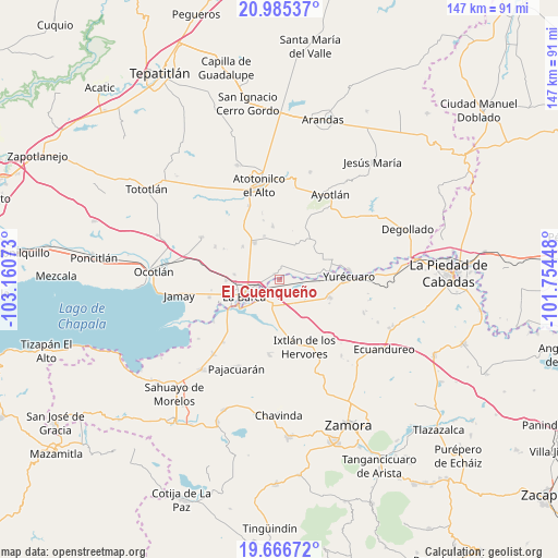
El Cuenqueño GPS coordinates[2]
20° 19' 38.82" North, 102° 27' 27.36" West
| Map corner | latitude | longitude |
|---|---|---|
| Upper-left | 20.98537°, | -103.16073° |
| Center: | 20.32745°, | -102.4576° |
| Lower-right: | 19.66672°, | -101.75448° |
| Map W x H: | 146.6×146.6 km | = 91.1×91.1mi |
| max Lat: | 32.7° ⇑35.9% North |
| El Cuenqueño: | 20.32745° |
| min Lat: | ⇓64.1% South 14.53588° |
| min Long | El Cuenqueño | max Long |
| -117.105° | -102.4576° | -86.73105° |
| W 16.2%⇐ | ⇒83.8% E |
Elevation
Elevation of El Cuenqueño is 1539 m = 5049 ft, and this is 285.3 m = 936 ft above average elevation for this country.
| Max E: |
3497 m = 11473 ft | 47.1% |
| El Cuenqueño | 1539 m 5049 ft | |
| Avg. | 1253.7 m = 4113 ft | |
Min E: |
-1 m = -3 ft | 52.9% |
See also: Mexico elevation on elevation.city.
Geographical zone
El Cuenqueño is located in North Torrid zone (between Equator and Tropic of Cancer). Distance of this Northern Tropic circle is 345.7 km =214.8 mi to North.| Distance of | km | miles | from El Cuenqueño |
|---|---|---|---|
| North Pole | 7746.9 | 4813.7 | to North |
| Arctic Circle | 5141 | 3194.5 | to North |
| Tropic Cancer | 345.7 | 214.8 | to North |
| Equator | 2260.2 | 1404.4 | to South |


Nearby cities:
15 places around El Cuenqueño: (largest is in red/bold)
• El Alvareño
3.6 km =2.2 mi,  144°
144°
• El Carmen
9.6 km =6 mi,  24°
24°
• El Gobernador
6.9 km =4.3 mi,  0°
0°
• El Loreto Occidental
2.2 km =1.4 mi,  319°
319°
• El Mirto
9.7 km =6 mi,  289°
289°
• La Barca
10.1 km =6.3 mi,  244°
244°
• La Paz de Ordaz
7.9 km =4.9 mi,  284°
284°
• La Puerta de Guamúchil
8.9 km =5.5 mi,  269°
269°
• Los Charcos
8.7 km =5.4 mi, 143°
• Los Pilares
8.8 km =5.5 mi,  91°
91°
• San Antonio de Rivas
4 km =2.5 mi,  50°
50°
• San Ramón
3 km =1.9 mi, 2°
• Santa Lucía
9.9 km =6.2 mi,  65°
65°
• Vista Hermosa de Negrete
6.5 km =4 mi,  196°
196°
• Zalamea
5.6 km =3.5 mi,  254°
254°
Sources, notices
• [Note1] Compared only with cities in Mexico existing in our database
• [Src1] Map data: © OpenStreetMap contributors (CC-BY-SA)
• [Src2] Other city data from geonames.org with taken over terms of usage.
• [Src3] Geographical zone / Annual Mean Temperature by Robert A. Rohde @ Wikipedia
