Duarte geodata
Duarte (Guanajuato) is a populated place; located in Mexico in America/Mexico_City (GMT-6) time zone. With population of 6,261 people, there are 1488 cities with bigger population in this country. Compared to other cities in Mexico, 77.7% of cities are located further ↓South; 77.6% of cities are located further →East and 67.7% of cities have lower elevation than Duarte. Note1


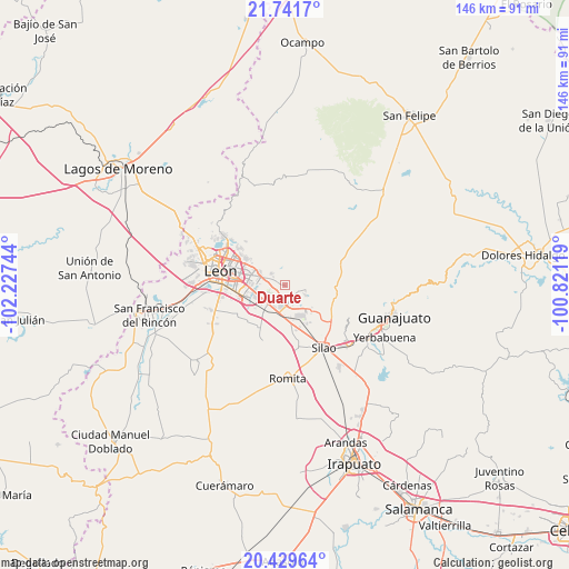
Duarte GPS coordinates[2]
21° 5' 13.632" North, 101° 31' 27.516" West
| Map corner | latitude | longitude |
|---|---|---|
| Upper-left | 21.7417°, | -102.22744° |
| Center: | 21.08712°, | -101.52431° |
| Lower-right: | 20.42964°, | -100.82119° |
| Map W x H: | 145.9×145.9 km | = 90.7×90.7mi |
| max Lat: | 32.7° ⇑22.3% North |
| Duarte: | 21.08712° |
| min Lat: | ⇓77.7% South 14.53588° |
| min Long | Duarte | max Long |
| -117.105° | -101.52431° | -86.73105° |
| W 22.4%⇐ | ⇒77.6% E |
Elevation
Elevation of Duarte is 1882 m = 6175 ft, and this is 628.3 m = 2061 ft above average elevation for this country.
| Max E: |
3497 m = 11473 ft | 32.3% |
| Duarte | 1882 m 6175 ft | |
| Avg. | 1253.7 m = 4113 ft | |
Min E: |
-1 m = -3 ft | 67.7% |
See also: Mexico elevation on elevation.city.
Geographical zone
Duarte is located in North Torrid zone (between Equator and Tropic of Cancer). Distance of this Northern Tropic circle is 261.3 km =162.4 mi to North.| Distance of | km | miles | from Duarte |
|---|---|---|---|
| North Pole | 7662.4 | 4761.2 | to North |
| Arctic Circle | 5056.5 | 3142 | to North |
| Tropic Cancer | 261.3 | 162.4 | to North |
| Equator | 2344.7 | 1456.9 | to South |


Nearby cities:
15 places around Duarte: (largest is in red/bold)
• Albarradones
5.6 km =3.5 mi,  157°
157°
• Arboledas de los López Primera Sección
7.7 km =4.8 mi,  233°
233°
• Comanjilla
5.9 km =3.7 mi,  114°
114°
• Cristo Rey
6.2 km =3.9 mi,  292°
292°
• Fraccionamiento Paraíso Real
6.5 km =4 mi,  295°
295°
• La Laborcita
3.6 km =2.2 mi,  306°
306°
• Ladrilleras del Refugio
3.1 km =1.9 mi,  264°
264°
• Las Coloradas
2.5 km =1.6 mi,  62°
62°
• Lomas de Comanjilla
6.1 km =3.8 mi,  185°
185°
• Lomas de la Loza
4.1 km =2.5 mi, 228°
• Loza de los Padres
2.8 km =1.7 mi, 232°
• Lucio Blanco (Los Gavilanes)
4.2 km =2.6 mi,  318°
318°
• San Francisco (Baños de Agua Caliente)
5.5 km =3.4 mi, 105°
• San Isidro de los Sauces
7.5 km =4.7 mi, 190°
• San Juan de Otates
4.7 km =2.9 mi, 312°
Sources, notices
• [Note1] Compared only with cities in Mexico existing in our database
• [Src1] Map data: © OpenStreetMap contributors (CC-BY-SA)
• [Src2] Other city data from geonames.org with taken over terms of usage.
• [Src3] Geographical zone / Annual Mean Temperature by Robert A. Rohde @ Wikipedia
