Las Coloradas geodata
Las Coloradas (Guanajuato) is a populated place; located in Mexico in America/Mexico_City (GMT-6) time zone. With population of 647 people, there are 13375 cities with bigger population in this country. Compared to other cities in Mexico, 77.8% of cities are located further ↓South; 77.4% of cities are located further →East and 72.1% of cities have lower elevation than Las Coloradas. Note1


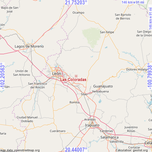
Las Coloradas GPS coordinates[2]
21° 5' 51" North, 101° 30' 9" West
| Map corner | latitude | longitude |
|---|---|---|
| Upper-left | 21.75203°, | -102.20563° |
| Center: | 21.0975°, | -101.5025° |
| Lower-right: | 20.44007°, | -100.79938° |
| Map W x H: | 145.9×145.9 km | = 90.7×90.7mi |
| max Lat: | 32.7° ⇑22.2% North |
| Las Coloradas: | 21.0975° |
| min Lat: | ⇓77.8% South 14.53588° |
| min Long | Las Coloradas | max Long |
| -117.105° | -101.5025° | -86.73105° |
| W 22.6%⇐ | ⇒77.4% E |
Elevation
Elevation of Las Coloradas is 1968 m = 6457 ft, and this is 714.3 m = 2344 ft above average elevation for this country.
| Max E: |
3497 m = 11473 ft | 27.9% |
| Las Coloradas | 1968 m 6457 ft | |
| Avg. | 1253.7 m = 4113 ft | |
Min E: |
-1 m = -3 ft | 72.1% |
See also: Mexico elevation on elevation.city.
Geographical zone
Las Coloradas is located in North Torrid zone (between Equator and Tropic of Cancer). Distance of this Northern Tropic circle is 260.1 km =161.6 mi to North.| Distance of | km | miles | from Las Coloradas |
|---|---|---|---|
| North Pole | 7661.2 | 4760.4 | to North |
| Arctic Circle | 5055.4 | 3141.3 | to North |
| Tropic Cancer | 260.1 | 161.6 | to North |
| Equator | 2345.8 | 1457.6 | to South |


Nearby cities:
15 places around Las Coloradas: (largest is in red/bold)
• Albarradones
6.4 km =4 mi,  181°
181°
• Comanjilla
4.7 km =2.9 mi,  139°
139°
• Cristo Rey
8 km =5 mi,  278°
278°
• Duarte
2.5 km =1.6 mi,  242°
242°
• Fraccionamiento Paraíso Real
8.3 km =5.2 mi, 281°
• La Laborcita
5.2 km =3.2 mi, 280°
• Ladrilleras del Refugio
5.5 km =3.4 mi,  254°
254°
• Loma de Yerbabuena
6.9 km =4.3 mi,  126°
126°
• Lomas de Comanjilla
7.7 km =4.8 mi,  201°
201°
• Lomas de la Loza
6.6 km =4.1 mi,  234°
234°
• Loza de los Padres
5.3 km =3.3 mi, 237°
• Lucio Blanco (Los Gavilanes)
5.4 km =3.4 mi,  291°
291°
• Salitrillo
8.3 km =5.2 mi, 144°
• San Francisco (Baños de Agua Caliente)
4 km =2.5 mi, 130°
• San Juan de Otates
6.1 km =3.8 mi, 289°
Sources, notices
• [Note1] Compared only with cities in Mexico existing in our database
• [Src1] Map data: © OpenStreetMap contributors (CC-BY-SA)
• [Src2] Other city data from geonames.org with taken over terms of usage.
• [Src3] Geographical zone / Annual Mean Temperature by Robert A. Rohde @ Wikipedia
