Comanjilla geodata
Comanjilla (Guanajuato) is a populated place; located in Mexico in America/Mexico_City (GMT-6) time zone. With population of 2,955 people, there are 3030 cities with bigger population in this country. Compared to other cities in Mexico, 77.4% of cities are located further ↓South; 77.2% of cities are located further →East and 67.9% of cities have lower elevation than Comanjilla. Note1


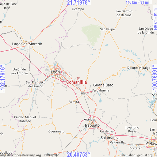
Comanjilla GPS coordinates[2]
21° 3' 54.36" North, 101° 28' 22.908" West
| Map corner | latitude | longitude |
|---|---|---|
| Upper-left | 21.71978°, | -102.17616° |
| Center: | 21.0651°, | -101.47303° |
| Lower-right: | 20.40753°, | -100.76991° |
| Map W x H: | 145.9×145.9 km | = 90.7×90.7mi |
| max Lat: | 32.7° ⇑22.6% North |
| Comanjilla: | 21.0651° |
| min Lat: | ⇓77.4% South 14.53588° |
| min Long | Comanjilla | max Long |
| -117.105° | -101.47303° | -86.73105° |
| W 22.8%⇐ | ⇒77.2% E |
Elevation
Elevation of Comanjilla is 1887 m = 6191 ft, and this is 633.3 m = 2078 ft above average elevation for this country.
| Max E: |
3497 m = 11473 ft | 32.1% |
| Comanjilla | 1887 m 6191 ft | |
| Avg. | 1253.7 m = 4113 ft | |
Min E: |
-1 m = -3 ft | 67.9% |
See also: Mexico elevation on elevation.city.
Geographical zone
Comanjilla is located in North Torrid zone (between Equator and Tropic of Cancer). Distance of this Northern Tropic circle is 263.7 km =163.9 mi to North.| Distance of | km | miles | from Comanjilla |
|---|---|---|---|
| North Pole | 7664.8 | 4762.7 | to North |
| Arctic Circle | 5059 | 3143.5 | to North |
| Tropic Cancer | 263.7 | 163.9 | to North |
| Equator | 2342.2 | 1455.4 | to South |


Nearby cities:
15 places around Comanjilla: (largest is in red/bold)
• Albarradones
4.2 km =2.6 mi,  228°
228°
• Chichimequillas
4.4 km =2.7 mi,  134°
134°
• Duarte
5.9 km =3.7 mi,  294°
294°
• La Esperanza del Refugio
7.8 km =4.8 mi,  220°
220°
• Las Coloradas
4.7 km =2.9 mi,  319°
319°
• Loma de Yerbabuena
2.5 km =1.6 mi,  101°
101°
• Lomas de Comanjilla
6.9 km =4.3 mi,  238°
238°
• Loza de los Padres
7.6 km =4.7 mi,  275°
275°
• Mezquite de Sotelo
7 km =4.3 mi,  206°
206°
• Paxtle
7.2 km =4.5 mi, 95°
• Providencia de Nápoles
4.9 km =3 mi,  161°
161°
• Salitrillo
3.6 km =2.2 mi,  151°
151°
• San Agustín de las Flores
7.4 km =4.6 mi, 149°
• San Francisco (Baños de Agua Caliente)
1 km =0.6 mi,  1°
1°
• Tuna Mansa
8.1 km =5 mi,  120°
120°
Sources, notices
• [Note1] Compared only with cities in Mexico existing in our database
• [Src1] Map data: © OpenStreetMap contributors (CC-BY-SA)
• [Src2] Other city data from geonames.org with taken over terms of usage.
• [Src3] Geographical zone / Annual Mean Temperature by Robert A. Rohde @ Wikipedia
