Cuxpala geodata
Cuxpala (Jalisco) is a populated place; located in Mexico in America/Mexico_City (GMT-6) time zone. With population of 1,369 people, there are 6339 cities with bigger population in this country. Compared to other cities in Mexico, 69.1% of cities are located further ↓South; 88.9% of cities are located further →East and 51.5% of cities have lower elevation than Cuxpala. Note1


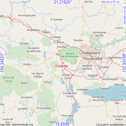
Cuxpala GPS coordinates[2]
20° 33' 33.66" North, 103° 38' 42.36" West
| Map corner | latitude | longitude |
|---|---|---|
| Upper-left | 21.21626°, | -104.34823° |
| Center: | 20.55935°, | -103.6451° |
| Lower-right: | 19.8996°, | -102.94198° |
| Map W x H: | 146.4×146.4 km | = 91×91mi |
| max Lat: | 32.7° ⇑30.9% North |
| Cuxpala: | 20.55935° |
| min Lat: | ⇓69.1% South 14.53588° |
| min Long | Cuxpala | max Long |
| -117.105° | -103.6451° | -86.73105° |
| W 11.1%⇐ | ⇒88.9% E |
Elevation
Elevation of Cuxpala is 1508 m = 4948 ft, and this is 254.3 m = 834 ft above average elevation for this country.
| Max E: |
3497 m = 11473 ft | 48.5% |
| Cuxpala | 1508 m 4948 ft | |
| Avg. | 1253.7 m = 4113 ft | |
Min E: |
-1 m = -3 ft | 51.5% |
See also: Mexico elevation on elevation.city.
Geographical zone
Cuxpala is located in North Torrid zone (between Equator and Tropic of Cancer). Distance of this Northern Tropic circle is 319.9 km =198.8 mi to North.| Distance of | km | miles | from Cuxpala |
|---|---|---|---|
| North Pole | 7721.1 | 4797.7 | to North |
| Arctic Circle | 5115.2 | 3178.4 | to North |
| Tropic Cancer | 319.9 | 198.8 | to North |
| Equator | 2286 | 1420.5 | to South |


Nearby cities:
15 places around Cuxpala: (largest is in red/bold)
• Acatlán de Juárez
16.2 km =10.1 mi,  159°
159°
• Ahuisculco
6.1 km =3.8 mi,  279°
279°
• Bellavista
14 km =8.7 mi,  176°
176°
• Cofradia
13.2 km =8.2 mi,  136°
136°
• Cruz Vieja
10.3 km =6.4 mi,  133°
133°
• Cuisillos
14.6 km =9.1 mi,  292°
292°
• El Ranchito (San Isidro)
15.2 km =9.4 mi, 287°
• El Refugio
15.9 km =9.9 mi,  321°
321°
• La Villita
3 km =1.9 mi, 130°
• Navajas
4.6 km =2.9 mi,  231°
231°
• San Isidro Mazatepec
5.3 km =3.3 mi, 140°
• San Juan de los Arcos
9.3 km =5.8 mi,  303°
303°
• Santa Cruz de la Loma (Tepetates)
12.7 km =7.9 mi, 128°
• Tala
12 km =7.5 mi,  330°
330°
• Villa Corona
16.1 km =10 mi,  187°
187°
Sources, notices
• [Note1] Compared only with cities in Mexico existing in our database
• [Src1] Map data: © OpenStreetMap contributors (CC-BY-SA)
• [Src2] Other city data from geonames.org with taken over terms of usage.
• [Src3] Geographical zone / Annual Mean Temperature by Robert A. Rohde @ Wikipedia
