Coyote geodata
Coyote (San Luis Potosí) is a populated place; located in Mexico in America/Mexico_City (GMT-6) time zone. With population of 507 people, there are 16589 cities with bigger population in this country. Compared to other cities in Mexico, 87.8% of cities are located further ↓South; 70.1% of cities are located further →East and 51% of cities have higher elevation than Coyote. Note1


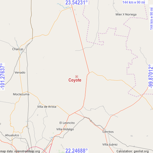
Coyote GPS coordinates[2]
22° 53' 46.104" North, 100° 34' 23.664" West
| Map corner | latitude | longitude |
|---|---|---|
| Upper-left | 23.54231°, | -101.27637° |
| Center: | 22.89614°, | -100.57324° |
| Lower-right: | 22.24688°, | -99.87012° |
| Map W x H: | 144×144 km | = 89.5×89.5mi |
| max Lat: | 32.7° ⇑12.2% North |
| Coyote: | 22.89614° |
| min Lat: | ⇓87.8% South 14.53588° |
| min Long | Coyote | max Long |
| -117.105° | -100.57324° | -86.73105° |
| W 29.9%⇐ | ⇒70.1% E |
Elevation
Elevation of Coyote is 1381 m = 4531 ft, and this is 127.3 m = 418 ft above average elevation for this country.
| Max E: |
3497 m = 11473 ft | 51% |
| Coyote | 1381 m 4531 ft | |
| Avg. | 1253.7 m = 4113 ft | |
Min E: |
-1 m = -3 ft | 49% |
See also: Mexico elevation on elevation.city.
Geographical zone
Coyote is located in North Torrid zone (between Equator and Tropic of Cancer). Distance of this Northern Tropic circle is 60.1 km =37.3 mi to North.| Distance of | km | miles | from Coyote |
|---|---|---|---|
| North Pole | 7461.2 | 4636.2 | to North |
| Arctic Circle | 4855.4 | 3017 | to North |
| Tropic Cancer | 60.1 | 37.3 | to North |
| Equator | 2545.8 | 1581.9 | to South |


Nearby cities:
15 places around Coyote: (largest is in red/bold)
• Charco Blanco
29.7 km =18.5 mi,  169°
169°
• El Charquito
32.3 km =20.1 mi,  202°
202°
• El Huisache
18.2 km =11.3 mi,  83°
83°
• Entronque de Matehuala (El Huizache)
12.1 km =7.5 mi,  74°
74°
• La Pólvora
24.4 km =15.2 mi, 81°
• La Tapona
14 km =8.7 mi,  211°
211°
• Norias del Refugio
16.7 km =10.4 mi,  38°
38°
• Núñez
24 km =14.9 mi,  163°
163°
• Peyote
27 km =16.8 mi,  186°
186°
• Pozas de Santa Ana
15.5 km =9.6 mi,  128°
128°
• Salitrillo
31.7 km =19.7 mi, 209°
• San Juan sin Agua
9.9 km =6.2 mi,  62°
62°
• Santa Rosa La Masita
29.2 km =18.1 mi,  352°
352°
• Santa Teresa
13.5 km =8.4 mi,  12°
12°
• Santo Domingo
29.9 km =18.6 mi,  96°
96°
Sources, notices
• [Note1] Compared only with cities in Mexico existing in our database
• [Src1] Map data: © OpenStreetMap contributors (CC-BY-SA)
• [Src2] Other city data from geonames.org with taken over terms of usage.
• [Src3] Geographical zone / Annual Mean Temperature by Robert A. Rohde @ Wikipedia
