Copala geodata
Copala (Sinaloa) is a populated place; located in Mexico in America/Mazatlan (GMT-7) time zone. With population of 506 people, there are 16626 cities with bigger population in this country. Compared to other cities in Mexico, 88.8% of cities are located further ↓South; 93.7% of cities are located further →East and 67.7% of cities have higher elevation than Copala. Note1


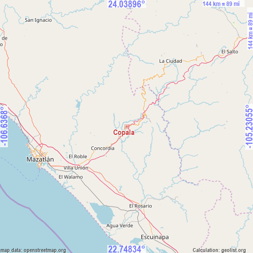
Copala GPS coordinates[2]
23° 23' 42.792" North, 105° 56' 1.212" West
| Map corner | latitude | longitude |
|---|---|---|
| Upper-left | 24.03896°, | -106.6368° |
| Center: | 23.39522°, | -105.93367° |
| Lower-right: | 22.74834°, | -105.23055° |
| Map W x H: | 143.5×143.5 km | = 89.2×89.2mi |
| max Lat: | 32.7° ⇑11.2% North |
| Copala: | 23.39522° |
| min Lat: | ⇓88.8% South 14.53588° |
| min Long | Copala | max Long |
| -117.105° | -105.93367° | -86.73105° |
| W 6.3%⇐ | ⇒93.7% E |
Elevation
Elevation of Copala is 544 m = 1785 ft, and this is 709.7 m = 2328 ft below average elevation for this country.
| Max E: |
3497 m = 11473 ft | 67.7% |
| Avg. | 1253.7 m = 4113 ft | |
| Copala | 544 m = 1785 ft | |
Min E: |
-1 m = -3 ft | 32.3% |
See also: Mexico elevation on elevation.city.
Geographical zone
Copala is located in North Torrid zone (between Equator and Tropic of Cancer). Distance of this Northern Tropic circle is 4.6 km =2.9 mi to North.| Distance of | km | miles | from Copala |
|---|---|---|---|
| North Pole | 7405.8 | 4601.7 | to North |
| Arctic Circle | 4799.9 | 2982.5 | to North |
| Tropic Cancer | 4.6 | 2.9 | to North |
| Equator | 2601.3 | 1616.4 | to South |


Nearby cities:
15 places around Copala: (largest is in red/bold)
• Chele
21.6 km =13.4 mi,  169°
169°
• Concordia
17.9 km =11.1 mi,  227°
227°
• El Bajío
30.7 km =19.1 mi,  251°
251°
• El Palmito
21 km =13 mi,  27°
27°
• El Recodo
28.5 km =17.7 mi,  272°
272°
• El Verde
20.8 km =12.9 mi,  260°
260°
• La Concepción
24 km =14.9 mi, 269°
• La Petaca
13.7 km =8.5 mi,  75°
75°
• Malpica
25.5 km =15.8 mi, 231°
• Mesillas
20.2 km =12.6 mi,  215°
215°
• Potrerillos
12.6 km =7.8 mi,  59°
59°
• Santa Lucía
9.5 km =5.9 mi, 60°
• Siqueros
32 km =19.9 mi, 259°
• Tepuxta
27.2 km =16.9 mi, 274°
• Zavala
19.1 km =11.9 mi, 255°
Sources, notices
• [Note1] Compared only with cities in Mexico existing in our database
• [Src1] Map data: © OpenStreetMap contributors (CC-BY-SA)
• [Src2] Other city data from geonames.org with taken over terms of usage.
• [Src3] Geographical zone / Annual Mean Temperature by Robert A. Rohde @ Wikipedia
