Santa Lucía geodata
Santa Lucía (Sinaloa) is a populated place; located in Mexico in America/Mazatlan (GMT-7) time zone. With population of 569 people, there are 15027 cities with bigger population in this country. Compared to other cities in Mexico, 88.9% of cities are located further ↓South; 93.6% of cities are located further →East and 55.4% of cities have higher elevation than Santa Lucía. Note1


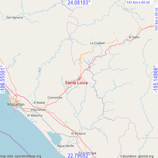
Santa Lucía GPS coordinates[2]
23° 26' 15" North, 105° 51' 10.008" West
| Map corner | latitude | longitude |
|---|---|---|
| Upper-left | 24.08103°, | -106.55591° |
| Center: | 23.4375°, | -105.85278° |
| Lower-right: | 22.79082°, | -105.14966° |
| Map W x H: | 143.5×143.5 km | = 89.2×89.2mi |
| max Lat: | 32.7° ⇑11.1% North |
| Santa Lucía: | 23.4375° |
| min Lat: | ⇓88.9% South 14.53588° |
| min Long | Santa Lucía | max Long |
| -117.105° | -105.85278° | -86.73105° |
| W 6.4%⇐ | ⇒93.6% E |
Elevation
Elevation of Santa Lucía is 1182 m = 3878 ft, and this is 71.7 m = 235 ft below average elevation for this country.
| Max E: |
3497 m = 11473 ft | 55.4% |
| Avg. | 1253.7 m = 4113 ft | |
| Santa Lucía | 1182 m = 3878 ft | |
Min E: |
-1 m = -3 ft | 44.6% |
See also: Mexico elevation on elevation.city.
Geographical zone
Santa Lucía is located in North temperate zone (between Tropic of Cancer and the Arctic Circle). Distance of this Northern Tropic circle is 0.1 km =0.1 mi to South.| Distance of | km | miles | from Santa Lucía |
|---|---|---|---|
| North Pole | 7401.1 | 4598.8 | to North |
| Arctic Circle | 4795.2 | 2979.6 | to North |
| Tropic Cancer | 0.1 | 0.1 | to South |
| Equator | 2606 | 1619.3 | to South |


Nearby cities:
15 places around Santa Lucía: (largest is in red/bold)
• Chavarría Nuevo
35.7 km =22.2 mi,  48°
48°
• Chele
26.2 km =16.3 mi,  189°
189°
• Concordia
27.3 km =17 mi,  232°
232°
• Copala
9.5 km =5.9 mi,  240°
240°
• El Palmito
14 km =8.7 mi,  6°
6°
• El Tecomate de la Noria
31.8 km =19.8 mi,  323°
323°
• El Verde
29.9 km =18.6 mi,  254°
254°
• La Concepción
32.6 km =20.3 mi,  261°
261°
• La Petaca
5.2 km =3.2 mi,  103°
103°
• Malpica
35 km =21.7 mi, 234°
• Mesa de San Pedro
26.7 km =16.6 mi, 100°
• Mesillas
29.1 km =18.1 mi,  223°
223°
• Potrerillos
3.1 km =1.9 mi,  55°
55°
• Tepuxta
35.4 km =22 mi,  265°
265°
• Zavala
28.4 km =17.6 mi, 250°
Sources, notices
• [Note1] Compared only with cities in Mexico existing in our database
• [Src1] Map data: © OpenStreetMap contributors (CC-BY-SA)
• [Src2] Other city data from geonames.org with taken over terms of usage.
• [Src3] Geographical zone / Annual Mean Temperature by Robert A. Rohde @ Wikipedia
