Comonfort geodata
Comonfort (Guanajuato) is a seat of a second-order administrative division; located in Mexico in America/Mexico_City (GMT-6) time zone. With population of 23,683 people, there are 430 cities with bigger population in this country. Compared to other cities in Mexico, 72% of cities are located further ↓South; 71.5% of cities are located further →East and 64% of cities have lower elevation than Comonfort. Note1


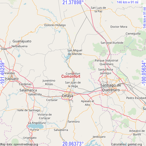
Comonfort GPS coordinates[2]
20° 43' 22.008" North, 100° 45' 34.056" West
| Map corner | latitude | longitude |
|---|---|---|
| Upper-left | 21.37898°, | -101.46259° |
| Center: | 20.72278°, | -100.75946° |
| Lower-right: | 20.06373°, | -100.05634° |
| Map W x H: | 146.2×146.2 km | = 90.8×90.8mi |
| max Lat: | 32.7° ⇑28% North |
| Comonfort: | 20.72278° |
| min Lat: | ⇓72% South 14.53588° |
| min Long | Comonfort | max Long |
| -117.105° | -100.75946° | -86.73105° |
| W 28.5%⇐ | ⇒71.5% E |
Elevation
Elevation of Comonfort is 1800 m = 5906 ft, and this is 546.3 m = 1792 ft above average elevation for this country.
| Max E: |
3497 m = 11473 ft | 36% |
| Comonfort | 1800 m 5906 ft | |
| Avg. | 1253.7 m = 4113 ft | |
Min E: |
-1 m = -3 ft | 64% |
See also: Mexico elevation on elevation.city.
Geographical zone
Comonfort is located in North Torrid zone (between Equator and Tropic of Cancer). Distance of this Northern Tropic circle is 301.8 km =187.5 mi to North.| Distance of | km | miles | from Comonfort |
|---|---|---|---|
| North Pole | 7702.9 | 4786.4 | to North |
| Arctic Circle | 5097 | 3167.1 | to North |
| Tropic Cancer | 301.8 | 187.5 | to North |
| Equator | 2304.2 | 1431.8 | to South |


Nearby cities:
15 places around Comonfort: (largest is in red/bold)
• Empalme Escobedo
5.7 km =3.5 mi,  166°
166°
• Guadalupe
7.7 km =4.8 mi, 171°
• Jalpilla
4.1 km =2.5 mi,  76°
76°
• La Borunda
9.4 km =5.8 mi, 84°
• La Laguna
3.8 km =2.4 mi,  237°
237°
• Las Gallinas
6 km =3.7 mi,  59°
59°
• Las Trojas
2.6 km =1.6 mi, 239°
• Morales
8.1 km =5 mi,  319°
319°
• Neutla
8.5 km =5.3 mi,  258°
258°
• Orduña de Abajo
4.6 km =2.9 mi,  328°
328°
• Orduña de Arriba
5.9 km =3.7 mi, 324°
• Rinconcillo (Rinconcillo de los Remedios)
8.7 km =5.4 mi, 327°
• San Antonio Espinoza
8.7 km =5.4 mi,  206°
206°
• San Isidro (La Loma)
2.8 km =1.7 mi,  216°
216°
• San Pablo
9 km =5.6 mi, 322°
Sources, notices
• [Note1] Compared only with cities in Mexico existing in our database
• [Src1] Map data: © OpenStreetMap contributors (CC-BY-SA)
• [Src2] Other city data from geonames.org with taken over terms of usage.
• [Src3] Geographical zone / Annual Mean Temperature by Robert A. Rohde @ Wikipedia
