Guadalupe geodata
Guadalupe (Guanajuato) is a populated place; located in Mexico in America/Mexico_City (GMT-6) time zone. With population of 507 people, there are 16589 cities with bigger population in this country. Compared to other cities in Mexico, 71% of cities are located further ↓South; 71.4% of cities are located further →East and 63.6% of cities have lower elevation than Guadalupe. Note1


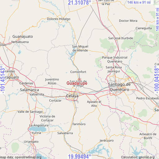
Guadalupe GPS coordinates[2]
20° 39' 15.408" North, 100° 44' 53.88" West
| Map corner | latitude | longitude |
|---|---|---|
| Upper-left | 21.31078°, | -101.45143° |
| Center: | 20.65428°, | -100.7483° |
| Lower-right: | 19.99494°, | -100.04518° |
| Map W x H: | 146.3×146.3 km | = 90.9×90.9mi |
| max Lat: | 32.7° ⇑29% North |
| Guadalupe: | 20.65428° |
| min Lat: | ⇓71% South 14.53588° |
| min Long | Guadalupe | max Long |
| -117.105° | -100.7483° | -86.73105° |
| W 28.6%⇐ | ⇒71.4% E |
Elevation
Elevation of Guadalupe is 1792 m = 5879 ft, and this is 538.3 m = 1766 ft above average elevation for this country.
| Max E: |
3497 m = 11473 ft | 36.4% |
| Guadalupe | 1792 m 5879 ft | |
| Avg. | 1253.7 m = 4113 ft | |
Min E: |
-1 m = -3 ft | 63.6% |
See also: Mexico elevation on elevation.city.
Geographical zone
Guadalupe is located in North Torrid zone (between Equator and Tropic of Cancer). Distance of this Northern Tropic circle is 309.4 km =192.3 mi to North.| Distance of | km | miles | from Guadalupe |
|---|---|---|---|
| North Pole | 7710.5 | 4791.1 | to North |
| Arctic Circle | 5104.6 | 3171.9 | to North |
| Tropic Cancer | 309.4 | 192.3 | to North |
| Equator | 2296.5 | 1427 | to South |


Nearby cities:
15 places around Guadalupe: (largest is in red/bold)
• Comonfort
7.7 km =4.8 mi,  351°
351°
• Empalme Escobedo
2 km =1.2 mi,  4°
4°
• Galvanes
4 km =2.5 mi,  97°
97°
• Jauregui
7.5 km =4.7 mi,  156°
156°
• La Aurora
3.2 km =2 mi,  197°
197°
• La Concepción
6.5 km =4 mi,  228°
228°
• La Laguna
7.1 km =4.4 mi,  321°
321°
• Las Trojas
7.2 km =4.5 mi,  331°
331°
• Presa Blanca
4.8 km =3 mi,  252°
252°
• San Antonio Espinoza
5 km =3.1 mi,  267°
267°
• San Antonio Gallardo
3.5 km =2.2 mi,  215°
215°
• San Isidro (La Loma)
6 km =3.7 mi, 331°
• San Isidro de la Concepción
4.9 km =3 mi, 232°
• San José de la Presa
4.8 km =3 mi,  184°
184°
• San Juan de la Vega
3.5 km =2.2 mi, 202°
Sources, notices
• [Note1] Compared only with cities in Mexico existing in our database
• [Src1] Map data: © OpenStreetMap contributors (CC-BY-SA)
• [Src2] Other city data from geonames.org with taken over terms of usage.
• [Src3] Geographical zone / Annual Mean Temperature by Robert A. Rohde @ Wikipedia
