Cocula geodata
Cocula (Jalisco) is a populated place; located in Mexico in America/Mexico_City (GMT-6) time zone. With population of 14,548 people, there are 666 cities with bigger population in this country. Compared to other cities in Mexico, 64.8% of cities are located further ↓South; 89.5% of cities are located further →East and 51.8% of cities have higher elevation than Cocula. Note1


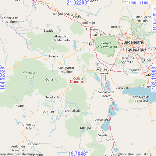
Cocula GPS coordinates[2]
20° 21' 54.612" North, 103° 49' 19.74" West
| Map corner | latitude | longitude |
|---|---|---|
| Upper-left | 21.02293°, | -104.52528° |
| Center: | 20.36517°, | -103.82215° |
| Lower-right: | 19.7046°, | -103.11903° |
| Map W x H: | 146.6×146.6 km | = 91.1×91.1mi |
| max Lat: | 32.7° ⇑35.2% North |
| Cocula: | 20.36517° |
| min Lat: | ⇓64.8% South 14.53588° |
| min Long | Cocula | max Long |
| -117.105° | -103.82215° | -86.73105° |
| W 10.5%⇐ | ⇒89.5% E |
Elevation
Elevation of Cocula is 1349 m = 4426 ft, and this is 95.3 m = 313 ft above average elevation for this country.
| Max E: |
3497 m = 11473 ft | 51.8% |
| Cocula | 1349 m 4426 ft | |
| Avg. | 1253.7 m = 4113 ft | |
Min E: |
-1 m = -3 ft | 48.2% |
See also: Mexico elevation on elevation.city.
Geographical zone
Cocula is located in North Torrid zone (between Equator and Tropic of Cancer). Distance of this Northern Tropic circle is 341.5 km =212.2 mi to North.| Distance of | km | miles | from Cocula |
|---|---|---|---|
| North Pole | 7742.7 | 4811.1 | to North |
| Arctic Circle | 5136.8 | 3191.9 | to North |
| Tropic Cancer | 341.5 | 212.2 | to North |
| Equator | 2264.4 | 1407 | to South |


Nearby cities:
15 places around Cocula: (largest is in red/bold)
• Atotonilco el Bajo
15.5 km =9.6 mi,  95°
95°
• Buenavista
8.3 km =5.2 mi,  112°
112°
• Camichinas
15.1 km =9.4 mi,  8°
8°
• El Crucero de Santa María
4.5 km =2.8 mi,  296°
296°
• El Salitre
16.6 km =10.3 mi,  347°
347°
• Estipa
10.3 km =6.4 mi,  91°
91°
• Juan Gil Preciado
9.9 km =6.2 mi, 85°
• La Estanzuela
13.2 km =8.2 mi,  343°
343°
• La Sauceda
9.8 km =6.1 mi, 9°
• Los Guerrero
11.7 km =7.3 mi,  317°
317°
• San Martín Hidalgo
13.6 km =8.5 mi,  305°
305°
• San Nicolás
11.4 km =7.1 mi,  1°
1°
• Santa Cruz de las Flores
13.6 km =8.5 mi,  283°
283°
• Santa María
5 km =3.1 mi, 322°
• Santa Teresa
6.1 km =3.8 mi,  138°
138°
Sources, notices
• [Note1] Compared only with cities in Mexico existing in our database
• [Src1] Map data: © OpenStreetMap contributors (CC-BY-SA)
• [Src2] Other city data from geonames.org with taken over terms of usage.
• [Src3] Geographical zone / Annual Mean Temperature by Robert A. Rohde @ Wikipedia
