La Sauceda geodata
La Sauceda (Jalisco) is a populated place; located in Mexico in America/Mexico_City (GMT-6) time zone. With population of 1,255 people, there are 6897 cities with bigger population in this country. Compared to other cities in Mexico, 66.8% of cities are located further ↓South; 89.4% of cities are located further →East and 53.3% of cities have higher elevation than La Sauceda. Note1


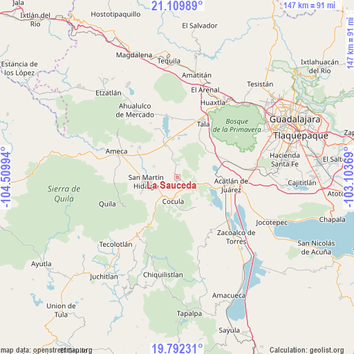
La Sauceda GPS coordinates[2]
20° 27' 9.036" North, 103° 48' 24.516" West
| Map corner | latitude | longitude |
|---|---|---|
| Upper-left | 21.10989°, | -104.50994° |
| Center: | 20.45251°, | -103.80681° |
| Lower-right: | 19.79231°, | -103.10369° |
| Map W x H: | 146.5×146.5 km | = 91×91mi |
| max Lat: | 32.7° ⇑33.2% North |
| La Sauceda: | 20.45251° |
| min Lat: | ⇓66.8% South 14.53588° |
| min Long | La Sauceda | max Long |
| -117.105° | -103.80681° | -86.73105° |
| W 10.6%⇐ | ⇒89.4% E |
Elevation
Elevation of La Sauceda is 1275 m = 4183 ft, and this is 21.3 m = 70 ft above average elevation for this country.
| Max E: |
3497 m = 11473 ft | 53.3% |
| La Sauceda | 1275 m 4183 ft | |
| Avg. | 1253.7 m = 4113 ft | |
Min E: |
-1 m = -3 ft | 46.7% |
See also: Mexico elevation on elevation.city.
Geographical zone
La Sauceda is located in North Torrid zone (between Equator and Tropic of Cancer). Distance of this Northern Tropic circle is 331.8 km =206.2 mi to North.| Distance of | km | miles | from La Sauceda |
|---|---|---|---|
| North Pole | 7733 | 4805.1 | to North |
| Arctic Circle | 5127.1 | 3185.8 | to North |
| Tropic Cancer | 331.8 | 206.2 | to North |
| Equator | 2274.1 | 1413.1 | to South |


Nearby cities:
15 places around La Sauceda: (largest is in red/bold)
• Buenavista
13.7 km =8.5 mi,  339°
339°
• Buenavista
14.3 km =8.9 mi,  154°
154°
• Camichinas
5.3 km =3.3 mi,  7°
7°
• Cocula
9.8 km =6.1 mi,  189°
189°
• El Crucero de Santa María
9.6 km =6 mi,  216°
216°
• El Salitre
8.3 km =5.2 mi,  320°
320°
• Estipa
13.3 km =8.3 mi,  139°
139°
• Juan Gil Preciado
12.1 km =7.5 mi, 137°
• La Estanzuela
6.1 km =3.8 mi,  298°
298°
• Labor de Medina
13 km =8.1 mi,  281°
281°
• Los Guerrero
9.6 km =6 mi,  263°
263°
• San Martín Hidalgo
12.8 km =8 mi, 261°
• San Nicolás
2.2 km =1.4 mi, 322°
• Santa María
7.4 km =4.6 mi, 219°
• Trapiche de Abra
9.8 km =6.1 mi,  352°
352°
Sources, notices
• [Note1] Compared only with cities in Mexico existing in our database
• [Src1] Map data: © OpenStreetMap contributors (CC-BY-SA)
• [Src2] Other city data from geonames.org with taken over terms of usage.
• [Src3] Geographical zone / Annual Mean Temperature by Robert A. Rohde @ Wikipedia
