Coahuayana Viejo geodata
Coahuayana Viejo (Michoacán) is a populated place; located in Mexico in America/Mexico_City (GMT-6) time zone. With population of 2,425 people, there are 3634 cities with bigger population in this country. Compared to other cities in Mexico, 69.5% of cities are located further ↑North; 89% of cities are located further →East and 91.6% of cities have higher elevation than Coahuayana Viejo. Note1


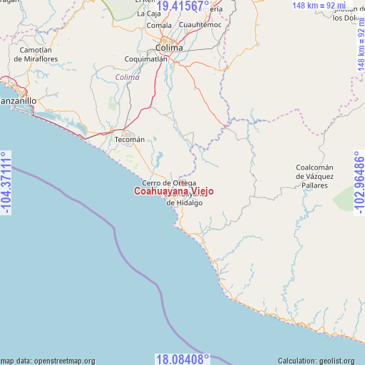
Coahuayana Viejo GPS coordinates[2]
18° 45' 4.284" North, 103° 40' 4.728" West
| Map corner | latitude | longitude |
|---|---|---|
| Upper-left | 19.41567°, | -104.37111° |
| Center: | 18.75119°, | -103.66798° |
| Lower-right: | 18.08408°, | -102.96486° |
| Map W x H: | 148.1×148.1 km | = 92×92mi |
| max Lat: | 32.7° ⇑69.5% North |
| Coahuayana Viejo: | 18.75119° |
| min Lat: | ⇓30.5% South 14.53588° |
| min Long | Coahuayana Viej | max Long |
| -117.105° | -103.66798° | -86.73105° |
| W 11%⇐ | ⇒89% E |
Elevation
Elevation of Coahuayana Viejo is 20 m = 66 ft, and this is 1233.7 m = 4048 ft below average elevation for this country.
| Max E: |
3497 m = 11473 ft | 91.6% |
| Avg. | 1253.7 m = 4113 ft | |
| Coahuayana Viejo | 20 m = 66 ft | |
Min E: |
-1 m = -3 ft | 8.4% |
See also: Mexico elevation on elevation.city.
Geographical zone
Coahuayana Viejo is located in North Torrid zone (between Equator and Tropic of Cancer). Distance of this Northern Tropic circle is 521 km =323.7 mi to North.| Distance of | km | miles | from Coahuayana Viejo |
|---|---|---|---|
| North Pole | 7922.1 | 4922.6 | to North |
| Arctic Circle | 5316.2 | 3303.3 | to North |
| Tropic Cancer | 521 | 323.7 | to North |
| Equator | 2084.9 | 1295.5 | to South |


Nearby cities:
15 places around Coahuayana Viejo: (largest is in red/bold)
• Aquila
24.1 km =15 mi,  134°
134°
• Caleras
35.2 km =21.9 mi,  320°
320°
• Cerro de Ortega
5.6 km =3.5 mi,  269°
269°
• Coahuayana de Hidalgo
5.5 km =3.4 mi,  172°
172°
• Cofradía de Morelos
22 km =13.7 mi,  306°
306°
• Colonia Ladislao Moreno
30.7 km =19.1 mi,  302°
302°
• Colonia Veinte de Noviembre (El Camalote)
4.2 km =2.6 mi,  64°
64°
• Ixtlahuacán
28.7 km =17.8 mi,  345°
345°
• La Placita de Morelos
25.7 km =16 mi,  160°
160°
• La Ticla
35 km =21.7 mi, 160°
• Santa María de Ostula
34.1 km =21.2 mi,  143°
143°
• Tecolapa
34.4 km =21.4 mi,  330°
330°
• Tecomán
28.8 km =17.9 mi, 309°
• Villa Victoria
31.4 km =19.5 mi,  88°
88°
• Zapotán
8.5 km =5.3 mi,  122°
122°
Sources, notices
• [Note1] Compared only with cities in Mexico existing in our database
• [Src1] Map data: © OpenStreetMap contributors (CC-BY-SA)
• [Src2] Other city data from geonames.org with taken over terms of usage.
• [Src3] Geographical zone / Annual Mean Temperature by Robert A. Rohde @ Wikipedia
