Santa María de Ostula geodata
Santa María de Ostula (Michoacán) is a populated place; located in Mexico in America/Mexico_City (GMT-6) time zone. With population of 972 people, there are 8937 cities with bigger population in this country. Compared to other cities in Mexico, 72.6% of cities are located further ↑North; 88.2% of cities are located further →East and 77.6% of cities have higher elevation than Santa María de Ostula. Note1
Current local time in Santa María de Ostula:
08:28 AM, WednesdayDifference from your time zone: hours


Santa María de Ostula GPS coordinates[2]
18° 30' 11.7" North, 103° 28' 38.208" West
| Map corner | latitude | longitude |
|---|---|---|
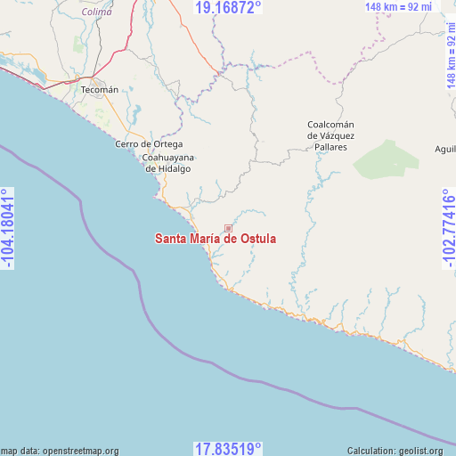
| Upper-left | 19.16872°, | -104.18041° |
| Center: | 18.50325°, | -103.47728° |
| Lower-right: | 17.83519°, | -102.77416° |
| Map W x H: | 148.3×148.3 km | = 92.1×92.1mi |
| max Lat: | 32.7° ⇑72.6% North |
| Santa María de Ostula: | 18.50325° |
| min Lat: | ⇓27.4% South 14.53588° |
| min Long | Santa María de | max Long |
| -117.105° | -103.47728° | -86.73105° |
| W 11.8%⇐ | ⇒88.2% E |
Elevation
Elevation of Santa María de Ostula is 140 m = 459 ft, and this is 1113.7 m = 3654 ft below average elevation for this country.
| Max E: |
3497 m = 11473 ft | 77.6% |
| Avg. | 1253.7 m = 4113 ft | |
| Santa María de Ostula | 140 m = 459 ft | |
Min E: |
-1 m = -3 ft | 22.4% |
See also: Mexico elevation on elevation.city.
Geographical zone
Santa María de Ostula is located in North Torrid zone (between Equator and Tropic of Cancer). Distance of this Northern Tropic circle is 548.6 km =340.9 mi to North.| Distance of | km | miles | from Santa María de Ostula |
|---|---|---|---|
| North Pole | 7949.7 | 4939.7 | to North |
| Arctic Circle | 5343.8 | 3320.5 | to North |
| Tropic Cancer | 548.6 | 340.9 | to North |
| Equator | 2057.4 | 1278.4 | to South |


Nearby cities:
15 places around Santa María de Ostula: (largest is in red/bold)
• Aquila
11.1 km =6.9 mi,  345°
345°
• Cerro de Ortega
37.7 km =23.4 mi,  316°
316°
• Coahuayana Viejo
34.1 km =21.2 mi, 323°
• Coahuayana de Hidalgo
29.4 km =18.3 mi, 318°
• Coalcomán de Vázquez Pallares
45.2 km =28.1 mi,  47°
47°
• Cofradía de Morelos
55.5 km =34.5 mi, 316°
• Colola
24 km =14.9 mi,  162°
162°
• Colonia Veinte de Noviembre (El Camalote)
33.6 km =20.9 mi,  330°
330°
• Ixtlahuacán
61.7 km =38.3 mi, 333°
• La Placita de Morelos
12.2 km =7.6 mi,  285°
285°
• La Ticla
9.8 km =6.1 mi,  236°
236°
• Maruata
28.8 km =17.9 mi,  153°
153°
• San Pedro Naranjestil
42.8 km =26.6 mi,  121°
121°
• Villa Victoria
30.5 km =19 mi,  21°
21°
• Zapotán
26.4 km =16.4 mi, 330°
Sources, notices
• [Note1] Compared only with cities in Mexico existing in our database
• [Src1] Map data: © OpenStreetMap contributors (CC-BY-SA)
• [Src2] Other city data from geonames.org with taken over terms of usage.
• [Src3] Geographical zone / Annual Mean Temperature by Robert A. Rohde @ Wikipedia
