Aquila geodata
Aquila (Michoacán) is a populated place; located in Mexico in America/Mexico_City (GMT-6) time zone. With population of 1,740 people, there are 4988 cities with bigger population in this country. Compared to other cities in Mexico, 71.4% of cities are located further ↑North; 88.3% of cities are located further →East and 75.6% of cities have higher elevation than Aquila. Note1


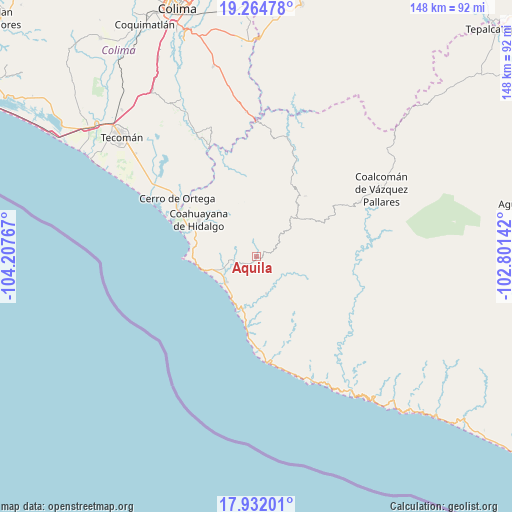
Aquila GPS coordinates[2]
18° 35' 58.92" North, 103° 30' 16.344" West
| Map corner | latitude | longitude |
|---|---|---|
| Upper-left | 19.26478°, | -104.20767° |
| Center: | 18.5997°, | -103.50454° |
| Lower-right: | 17.93201°, | -102.80142° |
| Map W x H: | 148.2×148.2 km | = 92.1×92.1mi |
| max Lat: | 32.7° ⇑71.4% North |
| Aquila: | 18.5997° |
| min Lat: | ⇓28.6% South 14.53588° |
| min Long | Aquila | max Long |
| -117.105° | -103.50454° | -86.73105° |
| W 11.7%⇐ | ⇒88.3% E |
Elevation
Elevation of Aquila is 201 m = 659 ft, and this is 1052.7 m = 3454 ft below average elevation for this country.
| Max E: |
3497 m = 11473 ft | 75.6% |
| Avg. | 1253.7 m = 4113 ft | |
| Aquila | 201 m = 659 ft | |
Min E: |
-1 m = -3 ft | 24.4% |
See also: Mexico elevation on elevation.city.
Geographical zone
Aquila is located in North Torrid zone (between Equator and Tropic of Cancer). Distance of this Northern Tropic circle is 537.8 km =334.2 mi to North.| Distance of | km | miles | from Aquila |
|---|---|---|---|
| North Pole | 7939 | 4933.1 | to North |
| Arctic Circle | 5333.1 | 3313.8 | to North |
| Tropic Cancer | 537.8 | 334.2 | to North |
| Equator | 2068.1 | 1285.1 | to South |


Nearby cities:
15 places around Aquila: (largest is in red/bold)
• Cerro de Ortega
28.4 km =17.6 mi,  306°
306°
• Coahuayana Viejo
24.1 km =15 mi, 314°
• Coahuayana de Hidalgo
20.1 km =12.5 mi,  304°
304°
• Coalcomán de Vázquez Pallares
41.3 km =25.7 mi,  61°
61°
• Cofradía de Morelos
46 km =28.6 mi, 310°
• Colola
35.1 km =21.8 mi,  163°
163°
• Colonia Veinte de Noviembre (El Camalote)
23 km =14.3 mi,  324°
324°
• Ixtlahuacán
50.9 km =31.6 mi,  331°
331°
• La Placita de Morelos
11.6 km =7.2 mi,  229°
229°
• La Ticla
17 km =10.6 mi,  198°
198°
• Maruata
39.7 km =24.7 mi, 156°
• San Pedro Naranjestil
51.5 km =32 mi,  130°
130°
• Santa María de Ostula
11.1 km =6.9 mi,  165°
165°
• Villa Victoria
22.6 km =14 mi,  38°
38°
• Zapotán
15.8 km =9.8 mi, 320°
Sources, notices
• [Note1] Compared only with cities in Mexico existing in our database
• [Src1] Map data: © OpenStreetMap contributors (CC-BY-SA)
• [Src2] Other city data from geonames.org with taken over terms of usage.
• [Src3] Geographical zone / Annual Mean Temperature by Robert A. Rohde @ Wikipedia
