Coahuayana de Hidalgo geodata
Coahuayana de Hidalgo (Michoacán) is a populated place; located in Mexico in America/Mexico_City (GMT-6) time zone. With population of 7,307 people, there are 1266 cities with bigger population in this country. Compared to other cities in Mexico, 70.2% of cities are located further ↑North; 88.9% of cities are located further →East and 86.3% of cities have higher elevation than Coahuayana de Hidalgo. Note1
Current local time in Coahuayana de Hidalgo:
06:46 AM, WednesdayDifference from your time zone: hours


Coahuayana de Hidalgo GPS coordinates[2]
18° 42' 8.064" North, 103° 39' 41.22" West
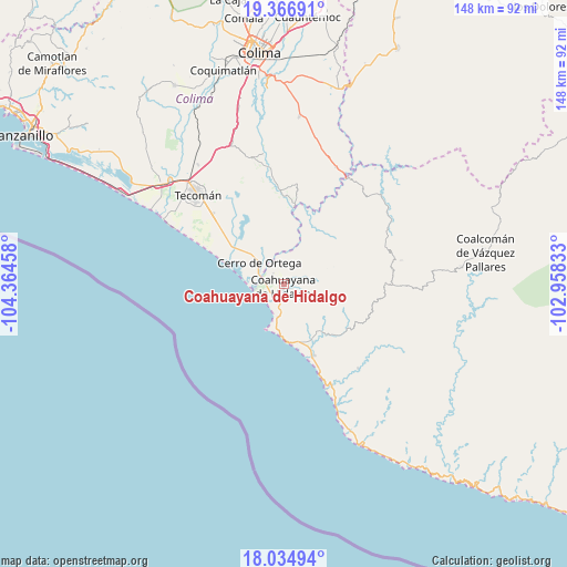
| Map corner | latitude | longitude |
|---|---|---|
| Upper-left | 19.36691°, | -104.36458° |
| Center: | 18.70224°, | -103.66145° |
| Lower-right: | 18.03494°, | -102.95833° |
| Map W x H: | 148.1×148.1 km | = 92×92mi |
| max Lat: | 32.7° ⇑70.2% North |
| Coahuayana de Hidalgo: | 18.70224° |
| min Lat: | ⇓29.8% South 14.53588° |
| min Long | Coahuayana de H | max Long |
| -117.105° | -103.66145° | -86.73105° |
| W 11.1%⇐ | ⇒88.9% E |
Elevation
Elevation of Coahuayana de Hidalgo is 37 m = 121 ft, and this is 1216.7 m = 3992 ft below average elevation for this country.
| Max E: |
3497 m = 11473 ft | 86.3% |
| Avg. | 1253.7 m = 4113 ft | |
| Coahuayana de Hidalgo | 37 m = 121 ft | |
Min E: |
-1 m = -3 ft | 13.7% |
See also: Mexico elevation on elevation.city.
Geographical zone
Coahuayana de Hidalgo is located in North Torrid zone (between Equator and Tropic of Cancer). Distance of this Northern Tropic circle is 526.4 km =327.1 mi to North.| Distance of | km | miles | from Coahuayana de Hidalgo |
|---|---|---|---|
| North Pole | 7927.6 | 4926 | to North |
| Arctic Circle | 5321.7 | 3306.8 | to North |
| Tropic Cancer | 526.4 | 327.1 | to North |
| Equator | 2079.5 | 1292.1 | to South |


Nearby cities:
15 places around Coahuayana de Hidalgo: (largest is in red/bold)
• Aquila
20.1 km =12.5 mi,  124°
124°
• Caleras
40 km =24.9 mi,  325°
325°
• Cerro de Ortega
8.3 km =5.2 mi,  310°
310°
• Coahuayana Viejo
5.5 km =3.4 mi,  352°
352°
• Cofradía de Morelos
26.1 km =16.2 mi, 314°
• Colonia Ladislao Moreno
34.4 km =21.4 mi, 309°
• Colonia Veinte de Noviembre (El Camalote)
7.9 km =4.9 mi,  23°
23°
• Ixtlahuacán
34.2 km =21.3 mi, 346°
• La Placita de Morelos
20.4 km =12.7 mi,  157°
157°
• La Ticla
29.7 km =18.5 mi, 157°
• Santa María de Ostula
29.4 km =18.3 mi,  138°
138°
• Tecolapa
39.5 km =24.5 mi, 333°
• Tecomán
33 km =20.5 mi,  316°
316°
• Villa Victoria
31.3 km =19.4 mi,  78°
78°
• Zapotán
6.6 km =4.1 mi, 82°
Sources, notices
• [Note1] Compared only with cities in Mexico existing in our database
• [Src1] Map data: © OpenStreetMap contributors (CC-BY-SA)
• [Src2] Other city data from geonames.org with taken over terms of usage.
• [Src3] Geographical zone / Annual Mean Temperature by Robert A. Rohde @ Wikipedia
