Ciénega Grande geodata
Ciénega Grande (Aguascalientes) is a populated place; located in Mexico in America/Mexico_City (GMT-6) time zone. With population of 3,348 people, there are 2715 cities with bigger population in this country. Compared to other cities in Mexico, 85.2% of cities are located further ↓South; 81.1% of cities are located further →East and 74% of cities have lower elevation than Ciénega Grande. Note1


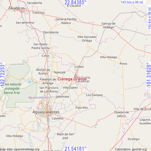
Ciénega Grande GPS coordinates[2]
22° 11' 39.624" North, 102° 1' 9.84" West
| Map corner | latitude | longitude |
|---|---|---|
| Upper-left | 22.84385°, | -102.72253° |
| Center: | 22.19434°, | -102.0194° |
| Lower-right: | 21.54181°, | -101.31628° |
| Map W x H: | 144.8×144.8 km | = 90×90mi |
| max Lat: | 32.7° ⇑14.8% North |
| Ciénega Grande: | 22.19434° |
| min Lat: | ⇓85.2% South 14.53588° |
| min Long | Ciénega Grande | max Long |
| -117.105° | -102.0194° | -86.73105° |
| W 18.9%⇐ | ⇒81.1% E |
Elevation
Elevation of Ciénega Grande is 2012 m = 6601 ft, and this is 758.3 m = 2488 ft above average elevation for this country.
| Max E: |
3497 m = 11473 ft | 26% |
| Ciénega Grande | 2012 m 6601 ft | |
| Avg. | 1253.7 m = 4113 ft | |
Min E: |
-1 m = -3 ft | 74% |
See also: Mexico elevation on elevation.city.
Geographical zone
Ciénega Grande is located in North Torrid zone (between Equator and Tropic of Cancer). Distance of this Northern Tropic circle is 138.1 km =85.8 mi to North.| Distance of | km | miles | from Ciénega Grande |
|---|---|---|---|
| North Pole | 7539.3 | 4684.7 | to North |
| Arctic Circle | 4933.4 | 3065.5 | to North |
| Tropic Cancer | 138.1 | 85.8 | to North |
| Equator | 2467.8 | 1533.4 | to South |


Nearby cities:
15 places around Ciénega Grande: (largest is in red/bold)
• Agua Gordita
8.6 km =5.3 mi,  143°
143°
• Asientos
8.7 km =5.4 mi,  304°
304°
• Bimbaletes
6.2 km =3.9 mi,  15°
15°
• Bimbaletes Aguascalientes (El Álamo)
4.5 km =2.8 mi,  0°
0°
• Bimbaletes Atlas
5.9 km =3.7 mi,  344°
344°
• Crisóstomos
4.6 km =2.9 mi,  31°
31°
• El Copetillo
6 km =3.7 mi,  161°
161°
• Guadalupe de Atlas
8.1 km =5 mi,  351°
351°
• La Loma (El Bajío)
7.2 km =4.5 mi, 28°
• Lázaro Cárdenas
2.7 km =1.7 mi,  197°
197°
• Molinos
8.5 km =5.3 mi,  245°
245°
• Norias de Guadalupe
8.5 km =5.3 mi,  5°
5°
• Plutarco Elías Calles
4 km =2.5 mi, 304°
• San Gil
1.5 km =0.9 mi, 350°
• Villa García
7.5 km =4.7 mi,  118°
118°
Sources, notices
• [Note1] Compared only with cities in Mexico existing in our database
• [Src1] Map data: © OpenStreetMap contributors (CC-BY-SA)
• [Src2] Other city data from geonames.org with taken over terms of usage.
• [Src3] Geographical zone / Annual Mean Temperature by Robert A. Rohde @ Wikipedia
