Agua Gordita geodata
Agua Gordita (Zacatecas) is a populated place; located in Mexico in America/Mexico_City (GMT-6) time zone. With population of 869 people, there are 10053 cities with bigger population in this country. Compared to other cities in Mexico, 84.9% of cities are located further ↓South; 80.8% of cities are located further →East and 77% of cities have lower elevation than Agua Gordita. Note1


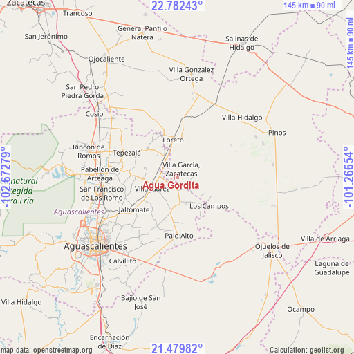
Agua Gordita GPS coordinates[2]
22° 7' 57.468" North, 101° 58' 10.776" West
| Map corner | latitude | longitude |
|---|---|---|
| Upper-left | 22.78243°, | -102.67279° |
| Center: | 22.13263°, | -101.96966° |
| Lower-right: | 21.47982°, | -101.26654° |
| Map W x H: | 144.8×144.8 km | = 90×90mi |
| max Lat: | 32.7° ⇑15.1% North |
| Agua Gordita: | 22.13263° |
| min Lat: | ⇓84.9% South 14.53588° |
| min Long | Agua Gordita | max Long |
| -117.105° | -101.96966° | -86.73105° |
| W 19.2%⇐ | ⇒80.8% E |
Elevation
Elevation of Agua Gordita is 2069 m = 6788 ft, and this is 815.3 m = 2675 ft above average elevation for this country.
| Max E: |
3497 m = 11473 ft | 23% |
| Agua Gordita | 2069 m 6788 ft | |
| Avg. | 1253.7 m = 4113 ft | |
Min E: |
-1 m = -3 ft | 77% |
See also: Mexico elevation on elevation.city.
Geographical zone
Agua Gordita is located in North Torrid zone (between Equator and Tropic of Cancer). Distance of this Northern Tropic circle is 145 km =90.1 mi to North.| Distance of | km | miles | from Agua Gordita |
|---|---|---|---|
| North Pole | 7546.1 | 4688.9 | to North |
| Arctic Circle | 4940.3 | 3069.8 | to North |
| Tropic Cancer | 145 | 90.1 | to North |
| Equator | 2460.9 | 1529.1 | to South |


Nearby cities:
15 places around Agua Gordita: (largest is in red/bold)
• Agua Gorda
5.7 km =3.5 mi,  120°
120°
• Ciénega Grande
8.6 km =5.3 mi,  323°
323°
• Crisóstomos
11.1 km =6.9 mi,  345°
345°
• El Copetillo
3.5 km =2.2 mi,  290°
290°
• Francisco Villa
5 km =3.1 mi,  179°
179°
• Granadas
11.5 km =7.1 mi,  107°
107°
• Lázaro Cárdenas
7.3 km =4.5 mi,  306°
306°
• Pilotos
10.7 km =6.6 mi,  174°
174°
• Plutarco Elías Calles
12.4 km =7.7 mi, 317°
• San Gil
9.9 km =6.2 mi,  327°
327°
• San José del Río
9.5 km =5.9 mi,  264°
264°
• Tierritas Blancas
5.6 km =3.5 mi,  104°
104°
• Villa García
3.5 km =2.2 mi,  24°
24°
• Villa Juárez
11.1 km =6.9 mi,  247°
247°
• Viudas de Poniente
12.3 km =7.6 mi, 254°
Sources, notices
• [Note1] Compared only with cities in Mexico existing in our database
• [Src1] Map data: © OpenStreetMap contributors (CC-BY-SA)
• [Src2] Other city data from geonames.org with taken over terms of usage.
• [Src3] Geographical zone / Annual Mean Temperature by Robert A. Rohde @ Wikipedia
