El Copetillo geodata
El Copetillo (Zacatecas) is a populated place; located in Mexico in America/Mexico_City (GMT-6) time zone. With population of 1,373 people, there are 6322 cities with bigger population in this country. Compared to other cities in Mexico, 84.9% of cities are located further ↓South; 81% of cities are located further →East and 76.9% of cities have lower elevation than El Copetillo. Note1


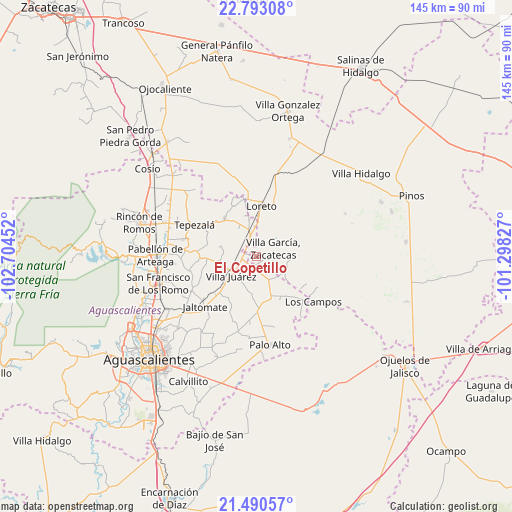
El Copetillo GPS coordinates[2]
22° 8' 35.988" North, 102° 0' 5.004" West
| Map corner | latitude | longitude |
|---|---|---|
| Upper-left | 22.79308°, | -102.70452° |
| Center: | 22.14333°, | -102.00139° |
| Lower-right: | 21.49057°, | -101.29827° |
| Map W x H: | 144.8×144.8 km | = 90×90mi |
| max Lat: | 32.7° ⇑15.1% North |
| El Copetillo: | 22.14333° |
| min Lat: | ⇓84.9% South 14.53588° |
| min Long | El Copetillo | max Long |
| -117.105° | -102.00139° | -86.73105° |
| W 19%⇐ | ⇒81% E |
Elevation
Elevation of El Copetillo is 2064 m = 6772 ft, and this is 810.3 m = 2658 ft above average elevation for this country.
| Max E: |
3497 m = 11473 ft | 23.1% |
| El Copetillo | 2064 m 6772 ft | |
| Avg. | 1253.7 m = 4113 ft | |
Min E: |
-1 m = -3 ft | 76.9% |
See also: Mexico elevation on elevation.city.
Geographical zone
El Copetillo is located in North Torrid zone (between Equator and Tropic of Cancer). Distance of this Northern Tropic circle is 143.8 km =89.4 mi to North.| Distance of | km | miles | from El Copetillo |
|---|---|---|---|
| North Pole | 7545 | 4688.2 | to North |
| Arctic Circle | 4939.1 | 3069 | to North |
| Tropic Cancer | 143.8 | 89.4 | to North |
| Equator | 2462.1 | 1529.9 | to South |


Nearby cities:
15 places around El Copetillo: (largest is in red/bold)
• Agua Gorda
9.2 km =5.7 mi,  116°
116°
• Agua Gordita
3.5 km =2.2 mi,  110°
110°
• Bimbaletes Aguascalientes (El Álamo)
10.3 km =6.4 mi,  349°
349°
• Ciénega Grande
6 km =3.7 mi,  341°
341°
• Crisóstomos
9.6 km =6 mi,  3°
3°
• Francisco Villa
7 km =4.3 mi,  151°
151°
• Lázaro Cárdenas
4.1 km =2.5 mi,  319°
319°
• Molinos
9.9 km =6.2 mi,  282°
282°
• Plutarco Elías Calles
9.4 km =5.8 mi,  327°
327°
• San Gil
7.5 km =4.7 mi, 343°
• San José del Río
6.6 km =4.1 mi,  250°
250°
• Tierritas Blancas
9 km =5.6 mi, 106°
• Villa García
5.1 km =3.2 mi,  66°
66°
• Villa Juárez
8.9 km =5.5 mi,  232°
232°
• Viudas de Poniente
9.7 km =6 mi,  242°
242°
Sources, notices
• [Note1] Compared only with cities in Mexico existing in our database
• [Src1] Map data: © OpenStreetMap contributors (CC-BY-SA)
• [Src2] Other city data from geonames.org with taken over terms of usage.
• [Src3] Geographical zone / Annual Mean Temperature by Robert A. Rohde @ Wikipedia
