Villa García geodata
Villa García (Zacatecas) is a seat of a second-order administrative division; located in Mexico in America/Mexico_City (GMT-6) time zone. With population of 6,535 people, there are 1435 cities with bigger population in this country. Compared to other cities in Mexico, 85% of cities are located further ↓South; 80.7% of cities are located further →East and 78.6% of cities have lower elevation than Villa García. Note1


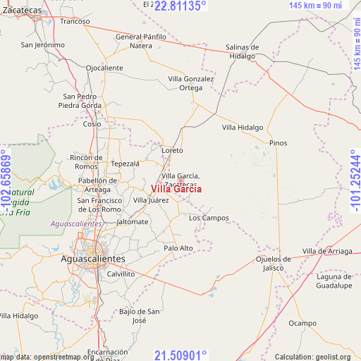
Villa García GPS coordinates[2]
22° 9' 42.084" North, 101° 57' 20.016" West
| Map corner | latitude | longitude |
|---|---|---|
| Upper-left | 22.81135°, | -102.65869° |
| Center: | 22.16169°, | -101.95556° |
| Lower-right: | 21.50901°, | -101.25244° |
| Map W x H: | 144.8×144.8 km | = 90×90mi |
| max Lat: | 32.7° ⇑15% North |
| Villa García: | 22.16169° |
| min Lat: | ⇓85% South 14.53588° |
| min Long | Villa García | max Long |
| -117.105° | -101.95556° | -86.73105° |
| W 19.3%⇐ | ⇒80.7% E |
Elevation
Elevation of Villa García is 2103 m = 6900 ft, and this is 849.3 m = 2786 ft above average elevation for this country.
| Max E: |
3497 m = 11473 ft | 21.4% |
| Villa García | 2103 m 6900 ft | |
| Avg. | 1253.7 m = 4113 ft | |
Min E: |
-1 m = -3 ft | 78.6% |
See also: Mexico elevation on elevation.city.
Geographical zone
Villa García is located in North Torrid zone (between Equator and Tropic of Cancer). Distance of this Northern Tropic circle is 141.8 km =88.1 mi to North.| Distance of | km | miles | from Villa García |
|---|---|---|---|
| North Pole | 7542.9 | 4686.9 | to North |
| Arctic Circle | 4937 | 3067.7 | to North |
| Tropic Cancer | 141.8 | 88.1 | to North |
| Equator | 2464.1 | 1531.1 | to South |


Nearby cities:
15 places around Villa García: (largest is in red/bold)
• Agua Gorda
7 km =4.3 mi,  150°
150°
• Agua Gordita
3.5 km =2.2 mi,  204°
204°
• Bimbaletes
10.8 km =6.7 mi,  333°
333°
• Bimbaletes Aguascalientes (El Álamo)
10.4 km =6.5 mi,  321°
321°
• Ciénega Grande
7.5 km =4.7 mi,  298°
298°
• Crisóstomos
8.6 km =5.3 mi, 331°
• El Copetillo
5.1 km =3.2 mi,  246°
246°
• Francisco Villa
8.3 km =5.2 mi,  189°
189°
• Granadas
11.7 km =7.3 mi,  125°
125°
• La Loma (El Bajío)
10.4 km =6.5 mi,  342°
342°
• Lázaro Cárdenas
7.4 km =4.6 mi,  278°
278°
• Plutarco Elías Calles
11.5 km =7.1 mi, 300°
• San Gil
8.5 km =5.3 mi,  306°
306°
• San José del Río
11.7 km =7.3 mi, 248°
• Tierritas Blancas
6.1 km =3.8 mi,  139°
139°
Sources, notices
• [Note1] Compared only with cities in Mexico existing in our database
• [Src1] Map data: © OpenStreetMap contributors (CC-BY-SA)
• [Src2] Other city data from geonames.org with taken over terms of usage.
• [Src3] Geographical zone / Annual Mean Temperature by Robert A. Rohde @ Wikipedia
