Calderón geodata
Calderón (Guanajuato) is a populated place; located in Mexico in America/Mexico_City (GMT-6) time zone. With population of 730 people, there are 11957 cities with bigger population in this country. Compared to other cities in Mexico, 73.4% of cities are located further ↓South; 71.9% of cities are located further →East and 68.9% of cities have lower elevation than Calderón. Note1


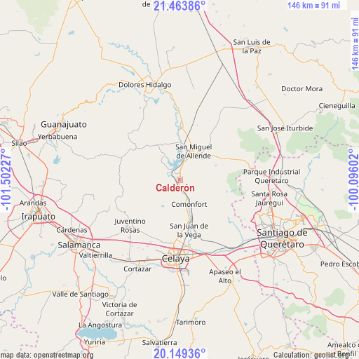
Calderón GPS coordinates[2]
20° 48' 28.944" North, 100° 47' 56.904" West
| Map corner | latitude | longitude |
|---|---|---|
| Upper-left | 21.46386°, | -101.50227° |
| Center: | 20.80804°, | -100.79914° |
| Lower-right: | 20.14936°, | -100.09602° |
| Map W x H: | 146.2×146.2 km | = 90.8×90.8mi |
| max Lat: | 32.7° ⇑26.6% North |
| Calderón: | 20.80804° |
| min Lat: | ⇓73.4% South 14.53588° |
| min Long | Calderón | max Long |
| -117.105° | -100.79914° | -86.73105° |
| W 28.1%⇐ | ⇒71.9% E |
Elevation
Elevation of Calderón is 1906 m = 6253 ft, and this is 652.3 m = 2140 ft above average elevation for this country.
| Max E: |
3497 m = 11473 ft | 31.1% |
| Calderón | 1906 m 6253 ft | |
| Avg. | 1253.7 m = 4113 ft | |
Min E: |
-1 m = -3 ft | 68.9% |
See also: Mexico elevation on elevation.city.
Geographical zone
Calderón is located in North Torrid zone (between Equator and Tropic of Cancer). Distance of this Northern Tropic circle is 292.3 km =181.6 mi to North.| Distance of | km | miles | from Calderón |
|---|---|---|---|
| North Pole | 7693.4 | 4780.5 | to North |
| Arctic Circle | 5087.5 | 3161.2 | to North |
| Tropic Cancer | 292.3 | 181.6 | to North |
| Equator | 2313.6 | 1437.6 | to South |


Nearby cities:
15 places around Calderón: (largest is in red/bold)
• Agustín González
8 km =5 mi,  316°
316°
• Comonfort
10.3 km =6.4 mi,  156°
156°
• Don Juan Xido de Abajo (Cabras de Begoña)
5.3 km =3.3 mi,  23°
23°
• Flores de Begoña
6.9 km =4.3 mi,  3°
3°
• La Huerta
3.6 km =2.2 mi,  295°
295°
• Las Trojas
10.9 km =6.8 mi,  169°
169°
• Morales
3.5 km =2.2 mi,  197°
197°
• Orduña de Abajo
5.8 km =3.6 mi, 162°
• Orduña de Arriba
4.7 km =2.9 mi, 171°
• Palmillas de San Juan
8.1 km =5 mi,  237°
237°
• Presa Allende
5.4 km =3.4 mi,  326°
326°
• Rinconcillo (Rinconcillo de los Remedios)
2.2 km =1.4 mi,  194°
194°
• San Marcos de Begoña
3.8 km =2.4 mi,  351°
351°
• San Pablo
2.8 km =1.7 mi,  209°
209°
• Santa Teresita de Don Diego
8.3 km =5.2 mi,  14°
14°
Sources, notices
• [Note1] Compared only with cities in Mexico existing in our database
• [Src1] Map data: © OpenStreetMap contributors (CC-BY-SA)
• [Src2] Other city data from geonames.org with taken over terms of usage.
• [Src3] Geographical zone / Annual Mean Temperature by Robert A. Rohde @ Wikipedia
